

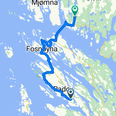
Treningstur 44km, Radøy
A cycling route starting in Manger, Hordaland, Norway.
Overview
About this route
Rute 44km:
Uthella-Helland-Kartveit-Marås-Sletta-Nordangevågen-Bøvågen-Ishuset-Helland-Uthella
- -:--
- Duration
- 44.2 km
- Distance
- 422 m
- Ascent
- 422 m
- Descent
- ---
- Avg. speed
- ---
- Max. altitude

Route quality
Waytypes & surfaces along the route
Waytypes
Quiet road
1.3 km
(3 %)
Access road
0.9 km
(2 %)
Undefined
42 km
(95 %)
Surfaces
Paved
9.7 km
(22 %)
Asphalt
9.7 km
(22 %)
Undefined
34.5 km
(78 %)
Continue with Bikemap
Use, edit, or download this cycling route
You would like to ride Treningstur 44km, Radøy or customize it for your own trip? Here is what you can do with this Bikemap route:
Free features
- Save this route as favorite or in collections
- Copy & plan your own version of this route
- Sync your route with Garmin or Wahoo
Premium features
Free trial for 3 days, or one-time payment. More about Bikemap Premium.
- Navigate this route on iOS & Android
- Export a GPX / KML file of this route
- Create your custom printout (try it for free)
- Download this route for offline navigation
Discover more Premium features.
Get Bikemap PremiumFrom our community
Other popular routes starting in Manger
 Bakkeintervall x 4
- Distance
- 27.8 km
- Ascent
- 334 m
- Descent
- 334 m
- Location
- Manger, Hordaland, Norway
 Treningstur, Radøy 37km
- Distance
- 37.3 km
- Ascent
- 249 m
- Descent
- 249 m
- Location
- Manger, Hordaland, Norway
 Treningstur 28km, Radøy
- Distance
- 28.9 km
- Ascent
- 387 m
- Descent
- 387 m
- Location
- Manger, Hordaland, Norway
 Manger - Eivindvik
- Distance
- 55.2 km
- Ascent
- 381 m
- Descent
- 417 m
- Location
- Manger, Hordaland, Norway
 049: Lunde– Bergen (DEVELOPED)
- Distance
- 43.2 km
- Ascent
- 967 m
- Descent
- 984 m
- Location
- Manger, Hordaland, Norway
 Treningstur 9km, Radøy
- Distance
- 9.2 km
- Ascent
- 89 m
- Descent
- 89 m
- Location
- Manger, Hordaland, Norway
 Treningstur 44km, Radøy
- Distance
- 44.2 km
- Ascent
- 422 m
- Descent
- 422 m
- Location
- Manger, Hordaland, Norway
 Manger
- Distance
- 11.9 km
- Ascent
- 163 m
- Descent
- 162 m
- Location
- Manger, Hordaland, Norway
Open it in the app