
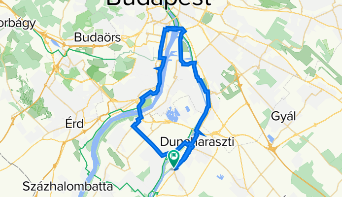
Taksony - Dunaparty Megálló - Kopaszi - Csepel - DH - Taksony
A cycling route starting in Taksony, Pest County, Hungary.
Overview
About this route
- -:--
- Duration
- 47.6 km
- Distance
- 139 m
- Ascent
- 141 m
- Descent
- ---
- Avg. speed
- 109 m
- Max. altitude

Route quality
Waytypes & surfaces along the route
Waytypes
Cycleway
21.4 km
(45 %)
Quiet road
13.8 km
(29 %)
Surfaces
Paved
40 km
(84 %)
Unpaved
1.9 km
(4 %)
Asphalt
39 km
(82 %)
Gravel
1.4 km
(3 %)
Continue with Bikemap
Use, edit, or download this cycling route
You would like to ride Taksony - Dunaparty Megálló - Kopaszi - Csepel - DH - Taksony or customize it for your own trip? Here is what you can do with this Bikemap route:
Free features
- Save this route as favorite or in collections
- Copy & plan your own version of this route
- Sync your route with Garmin or Wahoo
Premium features
Free trial for 3 days, or one-time payment. More about Bikemap Premium.
- Navigate this route on iOS & Android
- Export a GPX / KML file of this route
- Create your custom printout (try it for free)
- Download this route for offline navigation
Discover more Premium features.
Get Bikemap PremiumFrom our community
Other popular routes starting in Taksony
 Fadrusz utca 12 bikemap
- Distance
- 22.5 km
- Ascent
- 49 m
- Descent
- 46 m
- Location
- Taksony, Pest County, Hungary
 délegy-majos
- Distance
- 27.3 km
- Ascent
- 33 m
- Descent
- 30 m
- Location
- Taksony, Pest County, Hungary
 Mansfeld Péter utca, Taksony to Mansfeld Péter utca, Taksony
- Distance
- 9.5 km
- Ascent
- 130 m
- Descent
- 129 m
- Location
- Taksony, Pest County, Hungary
 TAKSONY KÖR
- Distance
- 94 km
- Ascent
- 74 m
- Descent
- 73 m
- Location
- Taksony, Pest County, Hungary
 GJU Fahrradtour 2018
- Distance
- 47.8 km
- Ascent
- 26 m
- Descent
- 36 m
- Location
- Taksony, Pest County, Hungary
 Taksony - nagy kör
- Distance
- 79.6 km
- Ascent
- 31 m
- Descent
- 33 m
- Location
- Taksony, Pest County, Hungary
 Fő út, Taksony to Mansfeld Péter utca, Taksony
- Distance
- 2.7 km
- Ascent
- 3 m
- Descent
- 10 m
- Location
- Taksony, Pest County, Hungary
 Bányatavak vidékén
- Distance
- 73.6 km
- Ascent
- 22 m
- Descent
- 24 m
- Location
- Taksony, Pest County, Hungary
Open it in the app