

Gambarogno Tour
A cycling route starting in Magadino, Canton Ticino, Switzerland.
Overview
About this route
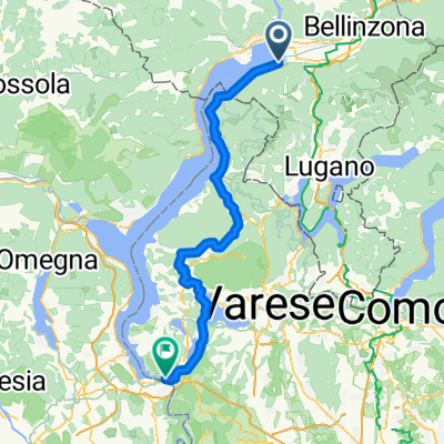
Diese Tour beginnt in Vira Gambarogno (Schweiz).<br />Von dort beginnt den Aufstieg nach "Alpe di Neggia" auf 1350 meter auf Asphalt (mittlere Steigung 10%- max 13%). Verplegungsmöglichkeiten langs der Strecke gibt es in Fosano und "Monti di Fosano", "Alpe di Neggia". Danach beginnt den Abstieg auf Asphalt nach "Indemini", sehr Schönes Altertümliches Dorf mit Verplegungsmöglichkeiten.
Danach geht es weiter nach "Biegno" (Italien). Vor dem Dorf beginnt der Aufstieg auf breiten Schotterweg nach "Cangili di Biegno" (mittlere Steigung 11%- max 17%). Von "Cancili di Biegno" geht der Schotterweg weiter nach "Passo della Forcora" mit schönen Aussichten auf den Lago Maggiore. Beim "Passo della Forcora" ist Verpflegungsmöglichkeit vorhanden. Vom "Passo della Forcora"gibt es verschiedene möglichkeiten. Der eingezeichnete Weg ist der Einfachste, um nach Maccagno zu gelangen, wobei bei Campagnano der schöne Aussichtspunkt nicht verpasst werden sollte. Wer Lust hat, kann beim Lago Delio einen weiteren Zwischenhalt einlegen (Baden ist allerdings nicht erlaupt). Von Maccagno geht es zurück nach Vira (Strasse ist sehr befahren).
Variante von Passo della Forcora:<br />Nach Monti di Pino und dann steiler Weg (25-30% Gefäll) nach Dirinella. Dieser Weg ist nur für starke Bremsen empfehlenswert.
- -:--
- Duration
- 55.5 km
- Distance
- 1,623 m
- Ascent
- 1,623 m
- Descent
- ---
- Avg. speed
- ---
- Max. altitude
Route highlights
Points of interest along the route
Point of interest after 10.7 km
Wasser ab kleinem Fluss
Point of interest after 12.9 km
Point of interest after 24.3 km
Continue with Bikemap
Use, edit, or download this cycling route
You would like to ride Gambarogno Tour or customize it for your own trip? Here is what you can do with this Bikemap route:
Free features
- Save this route as favorite or in collections
- Copy & plan your own version of this route
- Sync your route with Garmin or Wahoo
Premium features
Free trial for 3 days, or one-time payment. More about Bikemap Premium.
- Navigate this route on iOS & Android
- Export a GPX / KML file of this route
- Create your custom printout (try it for free)
- Download this route for offline navigation
Discover more Premium features.
Get Bikemap PremiumFrom our community
Other popular routes starting in Magadino
 Passo Neggia (1395m)
- Distance
- 57.9 km
- Ascent
- 3,081 m
- Descent
- 2,929 m
- Location
- Magadino, Canton Ticino, Switzerland
 Monte Tamaro Panorama
- Distance
- 31.6 km
- Ascent
- 756 m
- Descent
- 1,810 m
- Location
- Magadino, Canton Ticino, Switzerland
 Gambarogno Tour
- Distance
- 55.5 km
- Ascent
- 1,623 m
- Descent
- 1,623 m
- Location
- Magadino, Canton Ticino, Switzerland
 Via Cantonale 141, Magadino nach Via Muraccio 6, Ascona
- Distance
- 16.7 km
- Ascent
- 110 m
- Descent
- 106 m
- Location
- Magadino, Canton Ticino, Switzerland
 9 Vira- Mendrisio
- Distance
- 60 km
- Ascent
- 366 m
- Descent
- 251 m
- Location
- Magadino, Canton Ticino, Switzerland
 Magadino - Sesto Calende
- Distance
- 80.1 km
- Ascent
- 983 m
- Descent
- 986 m
- Location
- Magadino, Canton Ticino, Switzerland
 Passo Neggia
- Distance
- 56.9 km
- Ascent
- 3,100 m
- Descent
- 2,880 m
- Location
- Magadino, Canton Ticino, Switzerland
 Lago Runde
- Distance
- 167.7 km
- Ascent
- 1,873 m
- Descent
- 1,873 m
- Location
- Magadino, Canton Ticino, Switzerland
Open it in the app