BRT2012-MI: Drei-Täler-Tour - RTF des BRT2012 in Ulm - 72 km Strecke
A cycling route starting in Neu-Ulm, Bavaria, Germany.
Overview
About this route
BRT2012-MI: Drei-Täler-Tour - 72 km
RTF des BRT2012 in Ulm
Alle weiteren Hinweise zu dieser Strecke -> hier anklicken
Die Meinung sehr vieler Teilnehmer: Wieso gibt es bei einer solchen RTF nur eine Verpflegungsstelle?
Es hat sich ja seit Montag in Sachen Ausschilderung sehr wenig geändert. Wenn ßberhaupt gibt es pro Abzweig maximal einen Richtungspfeil. Fßr jeden km, den sich die Teilnehmer heute wieder verfahren haben, einen Euro und ich bräuchte mehrere Monate nicht arbeiten.
Frei nach dem Motto: Warum soll der Teilnehmer sich in der Ausschilderung sicher fßhlen. Er hat ja im Nachmittagsprogramm die MÜglichkeit, die Sehenswßrdigkeiten der Tour (gegen Geld) anzusehen. Während der RTF gilt allgemeines Pfeilsuchen und Kartenstudium.
- -:--
- Duration
- 87.9 km
- Distance
- 567 m
- Ascent
- 567 m
- Descent
- ---
- Avg. speed
- ---
- Avg. speed
Route quality
Waytypes & surfaces along the route
Waytypes
Busy road
25.1 km
(29 %)
Road
22.4 km
(25 %)
Surfaces
Paved
68.8 km
(78 %)
Unpaved
1.9 km
(2 %)
Asphalt
65.4 km
(74 %)
Paved (undefined)
3.4 km
(4 %)
Route highlights
Points of interest along the route
Point of interest after 41.3 km
Kontrolle <b>Laichingen</b> ist die einzige Verpflegungs- und Kontrollstelle auf der mittleren Strecke.
Continue with Bikemap
Use, edit, or download this cycling route
You would like to ride BRT2012-MI: Drei-Täler-Tour - RTF des BRT2012 in Ulm - 72 km Strecke or customize it for your own trip? Here is what you can do with this Bikemap route:
Free features
- Save this route as favorite or in collections
- Copy & plan your own version of this route
- Split it into stages to create a multi-day tour
- Sync your route with Garmin or Wahoo
Premium features
Free trial for 3 days, or one-time payment. More about Bikemap Premium.
- Navigate this route on iOS & Android
- Export a GPX / KML file of this route
- Create your custom printout (try it for free)
- Download this route for offline navigation
Discover more Premium features.
Get Bikemap PremiumFrom our community
Other popular routes starting in Neu-Ulm
- Donauroute Neu-Ulm-GĂźnzburg
- Distance
- 23.4 km
- Ascent
- 6 m
- Descent
- 29 m
- Location
- Neu-Ulm, Bavaria, Germany
- BRT2012-FR: Ăber die Alb und entlang des Kliffs - RTF des BRT2012 in Ulm - 72 km Strecke
- Distance
- 68.2 km
- Ascent
- 394 m
- Descent
- 394 m
- Location
- Neu-Ulm, Bavaria, Germany
- Radtour P15 25.06.2011
- Distance
- 64.9 km
- Ascent
- 246 m
- Descent
- 246 m
- Location
- Neu-Ulm, Bavaria, Germany
- BRT2012-MI: Drei-Täler-Tour - RTF des BRT2012 in Ulm - 103 km Strecke
- Distance
- 126 km
- Ascent
- 611 m
- Descent
- 610 m
- Location
- Neu-Ulm, Bavaria, Germany
- Feierabend-Tour MTB Ulm
- Distance
- 30.4 km
- Ascent
- 501 m
- Descent
- 498 m
- Location
- Neu-Ulm, Bavaria, Germany
- BRT2012-MO: Oberschwaben-Runde - RTF des BRT2012 in Ulm - 80 km Strecke
- Distance
- 79.5 km
- Ascent
- 206 m
- Descent
- 209 m
- Location
- Neu-Ulm, Bavaria, Germany
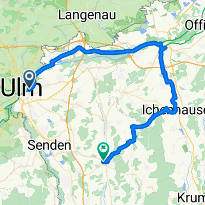
- BRT2012-DO: Zwischen Iller und Rot - RTF des BRT2012 in Ulm - 114 km Strecke
- Distance
- 108.9 km
- Ascent
- 384 m
- Descent
- 384 m
- Location
- Neu-Ulm, Bavaria, Germany
- Lauf in Ulm 13 km
- Distance
- 13.1 km
- Ascent
- 9 m
- Descent
- 14 m
- Location
- Neu-Ulm, Bavaria, Germany
Open it in the app