

Reichraming Hintergebirgsradweg Anlaufalm
A cycling route starting in Reichraming, Upper Austria, Austria.
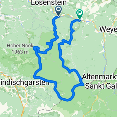
Overview
About this route
Simone & Gerald am 28.-29.Juli 2022 Unsere erste e-bike Tour - wunderbar!
Im Süden zwei unnötige Verfahrer bei km 22-25 und 42-43 :-)
Von der Anlaufalm runter gäbe es auch noch die direkte Strasse (km 37-46), das würde viele Höhenmeter sparen.
- 26 h 47 min
- Duration
- 63.9 km
- Distance
- 1,988 m
- Ascent
- 1,988 m
- Descent
- 2.4 km/h
- Avg. speed
- 987 m
- Max. altitude

Route quality
Waytypes & surfaces along the route
Waytypes
Track
47.9 km
(75 %)
Road
10.2 km
(16 %)
Surfaces
Paved
1.3 km
(2 %)
Unpaved
50.5 km
(79 %)
Gravel
33.2 km
(52 %)
Loose gravel
14.7 km
(23 %)
Continue with Bikemap
Use, edit, or download this cycling route
You would like to ride Reichraming Hintergebirgsradweg Anlaufalm or customize it for your own trip? Here is what you can do with this Bikemap route:
Free features
- Save this route as favorite or in collections
- Copy & plan your own version of this route
- Sync your route with Garmin or Wahoo
Premium features
Free trial for 3 days, or one-time payment. More about Bikemap Premium.
- Navigate this route on iOS & Android
- Export a GPX / KML file of this route
- Create your custom printout (try it for free)
- Download this route for offline navigation
Discover more Premium features.
Get Bikemap PremiumFrom our community
Other popular routes starting in Reichraming
 Molln /Schaunbergalm / Ebenforstalm
- Distance
- 33.1 km
- Ascent
- 1,034 m
- Descent
- 1,032 m
- Location
- Reichraming, Upper Austria, Austria
 Rakousko 2012-4.den-17.7.Út
- Distance
- 42.2 km
- Ascent
- 686 m
- Descent
- 594 m
- Location
- Reichraming, Upper Austria, Austria
 Hintergebirgsrunde
- Distance
- 36.1 km
- Ascent
- 1,059 m
- Descent
- 1,055 m
- Location
- Reichraming, Upper Austria, Austria
 Reichraming Hintergebirge Anlaufalm
- Distance
- 47.7 km
- Ascent
- 2,264 m
- Descent
- 2,263 m
- Location
- Reichraming, Upper Austria, Austria
 Anlaufalm
- Distance
- 53.5 km
- Ascent
- 871 m
- Descent
- 875 m
- Location
- Reichraming, Upper Austria, Austria
 Reichraming Ramble
- Distance
- 95.2 km
- Ascent
- 3,869 m
- Descent
- 3,842 m
- Location
- Reichraming, Upper Austria, Austria
 Breitenau, Ebenforstalm, Breitenau
- Distance
- 24.2 km
- Ascent
- 690 m
- Descent
- 683 m
- Location
- Reichraming, Upper Austria, Austria
 Reichraming R9
- Distance
- 41.3 km
- Ascent
- 537 m
- Descent
- 521 m
- Location
- Reichraming, Upper Austria, Austria
Open it in the app