

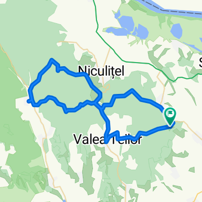
Telita-V Teilor-Izvoarele-Cataloi-Telita
A cycling route starting in Valea Teilor, Tulcea County, Romania.
Overview
About this route
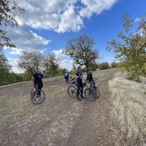
Smooth, but tough. The first part, aprox 10 km of forest road, very tough. Lot of mud, gravel.
Until you reach Valea Teilor, you'll have no water source.
Betwin the exist from forest, until Valea Teilor you have an old and very broked asphalt, very similar to offroad session.
Be very carefull with the road you take. It's possible to get wandered.
- -:--
- Duration
- 56.7 km
- Distance
- 441 m
- Ascent
- 441 m
- Descent
- ---
- Avg. speed
- ---
- Max. altitude

Route quality
Waytypes & surfaces along the route
Waytypes
Quiet road
14.7 km
(26 %)
Track
10.8 km
(19 %)
Undefined
31.2 km
(55 %)
Surfaces
Paved
31.2 km
(55 %)
Unpaved
1.7 km
(3 %)
Asphalt
31.2 km
(55 %)
Gravel
1.7 km
(3 %)
Undefined
23.8 km
(42 %)
Route highlights
Points of interest along the route

Point of interest after 0.3 km

Point of interest after 1.3 km

Point of interest after 4.3 km

Point of interest after 5.8 km

Point of interest after 7.8 km

Point of interest after 9.3 km

Point of interest after 20.5 km

Point of interest after 34.9 km

Point of interest after 55.9 km
Continue with Bikemap
Use, edit, or download this cycling route
You would like to ride Telita-V Teilor-Izvoarele-Cataloi-Telita or customize it for your own trip? Here is what you can do with this Bikemap route:
Free features
- Save this route as favorite or in collections
- Copy & plan your own version of this route
- Sync your route with Garmin or Wahoo
Premium features
Free trial for 3 days, or one-time payment. More about Bikemap Premium.
- Navigate this route on iOS & Android
- Export a GPX / KML file of this route
- Create your custom printout (try it for free)
- Download this route for offline navigation
Discover more Premium features.
Get Bikemap PremiumFrom our community
Other popular routes starting in Valea Teilor
 Traseu Celic Dere - Cocos
- Distance
- 63 km
- Ascent
- 875 m
- Descent
- 864 m
- Location
- Valea Teilor, Tulcea County, Romania
 Telita-V Teilor-Izvoarele-Cataloi-Telita
- Distance
- 56.7 km
- Ascent
- 441 m
- Descent
- 441 m
- Location
- Valea Teilor, Tulcea County, Romania
 Celik Dere Trail Run
- Distance
- 22.4 km
- Ascent
- 440 m
- Descent
- 443 m
- Location
- Valea Teilor, Tulcea County, Romania
 Restful route
- Distance
- 55.1 km
- Ascent
- 870 m
- Descent
- 893 m
- Location
- Valea Teilor, Tulcea County, Romania
 Celik Dere MTB Marathon
- Distance
- 38.8 km
- Ascent
- 618 m
- Descent
- 618 m
- Location
- Valea Teilor, Tulcea County, Romania
 Celic Dere-Niculitel-Nifon-Horia-Atmagea-Slava Cercheza-Stejaru-Ceamurlia de Sus-Beidaud-Ramnicu-Gradina-Cheia-Targusor-M. Kogalniceanu-Ovidiu-Constanta
- Distance
- 187.9 km
- Ascent
- 1,001 m
- Descent
- 1,063 m
- Location
- Valea Teilor, Tulcea County, Romania
 Tura Celic Dere 50km
- Distance
- 50.5 km
- Ascent
- 696 m
- Descent
- 708 m
- Location
- Valea Teilor, Tulcea County, Romania
 DJ229F, Frecatei to DJ229F, Frecatei
- Distance
- 54.4 km
- Ascent
- 1,208 m
- Descent
- 1,216 m
- Location
- Valea Teilor, Tulcea County, Romania
Open it in the app