

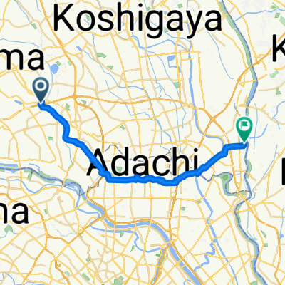
Shibakawa Cycling Road
A cycling route starting in Hatogaya-honchō, Saitama, Japan.
Overview
About this route
- 1 h 6 min
- Duration
- 15.5 km
- Distance
- 96 m
- Ascent
- 88 m
- Descent
- 14.1 km/h
- Avg. speed
- 29 m
- Max. altitude

Route photos


Route quality
Waytypes & surfaces along the route
Waytypes
Cycleway
8.7 km
(56 %)
Road
2 km
(13 %)
Surfaces
Paved
8 km
(52 %)
Asphalt
6.2 km
(40 %)
Paved (undefined)
1.9 km
(12 %)
Undefined
7.4 km
(48 %)
Continue with Bikemap
Use, edit, or download this cycling route
You would like to ride Shibakawa Cycling Road or customize it for your own trip? Here is what you can do with this Bikemap route:
Free features
- Save this route as favorite or in collections
- Copy & plan your own version of this route
- Sync your route with Garmin or Wahoo
Premium features
Free trial for 3 days, or one-time payment. More about Bikemap Premium.
- Navigate this route on iOS & Android
- Export a GPX / KML file of this route
- Create your custom printout (try it for free)
- Download this route for offline navigation
Discover more Premium features.
Get Bikemap PremiumFrom our community
Other popular routes starting in Hatogaya-honchō
 Healthy Road へルーシロード
- Distance
- 13.6 km
- Ascent
- 36 m
- Descent
- 32 m
- Location
- Hatogaya-honchō, Saitama, Japan
 13 芝川で「農」を体感するルート
- Distance
- 12.5 km
- Ascent
- 23 m
- Descent
- 25 m
- Location
- Hatogaya-honchō, Saitama, Japan
 763−2, 川口市 to 1丁目 20, 秩父市
- Distance
- 94 km
- Ascent
- 3,113 m
- Descent
- 2,878 m
- Location
- Hatogaya-honchō, Saitama, Japan
 BRM322-1
- Distance
- 153.1 km
- Ascent
- 990 m
- Descent
- 366 m
- Location
- Hatogaya-honchō, Saitama, Japan
 Shibakawa Cycling Road
- Distance
- 15.5 km
- Ascent
- 96 m
- Descent
- 88 m
- Location
- Hatogaya-honchō, Saitama, Japan
 一般県道足立さいたま自転車道線(芝川自転車道)
- Distance
- 11.5 km
- Ascent
- 23 m
- Descent
- 20 m
- Location
- Hatogaya-honchō, Saitama, Japan
 芝川サイクリングロード〜見沼代用水東縁〜見沼自然公園〜〃西縁
- Distance
- 31.6 km
- Ascent
- 78 m
- Descent
- 66 m
- Location
- Hatogaya-honchō, Saitama, Japan
 Hatogaya-honchō - Matsudo (1/2)
- Distance
- 24.2 km
- Ascent
- 44 m
- Descent
- 49 m
- Location
- Hatogaya-honchō, Saitama, Japan
Open it in the app