

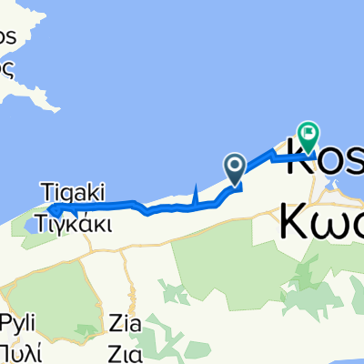
Grecja, Kos do Grecja, Kos
A cycling route starting in Kos, South Aegean, Greece.
Overview
About this route
- 4 h 28 min
- Duration
- 43.8 km
- Distance
- 659 m
- Ascent
- 659 m
- Descent
- 9.8 km/h
- Avg. speed
- 330 m
- Max. altitude

Route photos


Continue with Bikemap
Use, edit, or download this cycling route
You would like to ride Grecja, Kos do Grecja, Kos or customize it for your own trip? Here is what you can do with this Bikemap route:
Free features
- Save this route as favorite or in collections
- Copy & plan your own version of this route
- Sync your route with Garmin or Wahoo
Premium features
Free trial for 3 days, or one-time payment. More about Bikemap Premium.
- Navigate this route on iOS & Android
- Export a GPX / KML file of this route
- Create your custom printout (try it for free)
- Download this route for offline navigation
Discover more Premium features.
Get Bikemap PremiumFrom our community
Other popular routes starting in Kos
 Leoforos Georgiou Papandreou, Kos nach Amerikis 23–27, Kos
- Distance
- 68.9 km
- Ascent
- 1,383 m
- Descent
- 1,381 m
- Location
- Kos, South Aegean, Greece
 Grecja, Kos do Grecja, Kos
- Distance
- 43.8 km
- Ascent
- 659 m
- Descent
- 659 m
- Location
- Kos, South Aegean, Greece
 Kos Bergtour 2008
- Distance
- 32.3 km
- Ascent
- 831 m
- Descent
- 829 m
- Location
- Kos, South Aegean, Greece
 Kos Anja 16-260
- Distance
- 16.5 km
- Ascent
- 264 m
- Descent
- 265 m
- Location
- Kos, South Aegean, Greece
 Kos do Ολυμπίας, Kos
- Distance
- 19.5 km
- Ascent
- 41 m
- Descent
- 48 m
- Location
- Kos, South Aegean, Greece
 Ethelonton Palaion Polemiston Ko 98, Kos to V5QQ+GP, Tigaki
- Distance
- 10.8 km
- Ascent
- 47 m
- Descent
- 47 m
- Location
- Kos, South Aegean, Greece
 Route van Konstantinou Kanari 43, Kos
- Distance
- 12.7 km
- Ascent
- 95 m
- Descent
- 84 m
- Location
- Kos, South Aegean, Greece
 Los op Kos
- Distance
- 53.3 km
- Ascent
- 1,148 m
- Descent
- 1,148 m
- Location
- Kos, South Aegean, Greece
Open it in the app