
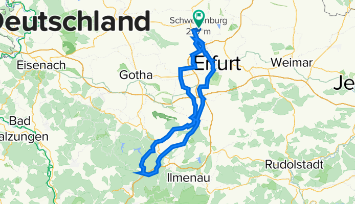
Walschleben - Oberhof - Walschleben
A cycling route starting in Walschleben, Thuringia, Germany.
Overview
About this route
- -:--
- Duration
- 126.3 km
- Distance
- 1,058 m
- Ascent
- 1,061 m
- Descent
- ---
- Avg. speed
- 797 m
- Max. altitude

Route quality
Waytypes & surfaces along the route
Waytypes
Road
30.3 km
(24 %)
Track
18.9 km
(15 %)
Surfaces
Paved
116.2 km
(92 %)
Asphalt
113.6 km
(90 %)
Paved (undefined)
1.3 km
(1 %)
Continue with Bikemap
Use, edit, or download this cycling route
You would like to ride Walschleben - Oberhof - Walschleben or customize it for your own trip? Here is what you can do with this Bikemap route:
Free features
- Save this route as favorite or in collections
- Copy & plan your own version of this route
- Split it into stages to create a multi-day tour
- Sync your route with Garmin or Wahoo
Premium features
Free trial for 3 days, or one-time payment. More about Bikemap Premium.
- Navigate this route on iOS & Android
- Export a GPX / KML file of this route
- Create your custom printout (try it for free)
- Download this route for offline navigation
Discover more Premium features.
Get Bikemap PremiumFrom our community
Other popular routes starting in Walschleben
 Runde von/nach Walschleben> Haßleben>Werningshausen>Sschallenburg>Alperstedt>Stotternheim Walschleben
- Distance
- 48.3 km
- Ascent
- 95 m
- Descent
- 98 m
- Location
- Walschleben, Thuringia, Germany
 Von Walschleben über die Fahner Höhen und zurück.
- Distance
- 20.4 km
- Ascent
- 323 m
- Descent
- 315 m
- Location
- Walschleben, Thuringia, Germany
 Walschleben - Grundmühle - Schöne Aussicht (Fahner Höhe) Walschleben
- Distance
- 27 km
- Ascent
- 278 m
- Descent
- 277 m
- Location
- Walschleben, Thuringia, Germany
 Im Haun 2, Walschleben nach Storchmühlenweg 1A, Erfurt
- Distance
- 13.9 km
- Ascent
- 47 m
- Descent
- 19 m
- Location
- Walschleben, Thuringia, Germany
 Walschleben - Craula - Walschleben
- Distance
- 117.5 km
- Ascent
- 722 m
- Descent
- 721 m
- Location
- Walschleben, Thuringia, Germany
 Radrunde von Walschleben nach Alperstedt
- Distance
- 16.5 km
- Ascent
- 36 m
- Descent
- 36 m
- Location
- Walschleben, Thuringia, Germany
 sonntagsausflug
- Distance
- 93.5 km
- Ascent
- 334 m
- Descent
- 335 m
- Location
- Walschleben, Thuringia, Germany
 Walschleben, Walschleben nach Am See 14, Walschleben
- Distance
- 20.6 km
- Ascent
- 373 m
- Descent
- 375 m
- Location
- Walschleben, Thuringia, Germany
Open it in the app