
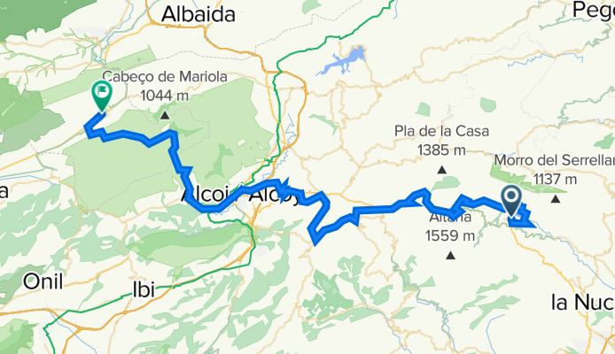
16/09: El Catell de ...-Bocairent A
A cycling route starting in Benimantell, Valencia, Spain.
Overview
About this route
- -:--
- Duration
- 76.1 km
- Distance
- 2,063 m
- Ascent
- 1,943 m
- Descent
- ---
- Avg. speed
- 967 m
- Max. altitude

Route quality
Waytypes & surfaces along the route
Waytypes
Quiet road
29.7 km
(39 %)
Road
17.5 km
(23 %)
Surfaces
Paved
12.9 km
(17 %)
Unpaved
0.8 km
(1 %)
Asphalt
11.4 km
(15 %)
Paved (undefined)
1.5 km
(2 %)
Continue with Bikemap
Use, edit, or download this cycling route
You would like to ride 16/09: El Catell de ...-Bocairent A or customize it for your own trip? Here is what you can do with this Bikemap route:
Free features
- Save this route as favorite or in collections
- Copy & plan your own version of this route
- Sync your route with Garmin or Wahoo
Premium features
Free trial for 3 days, or one-time payment. More about Bikemap Premium.
- Navigate this route on iOS & Android
- Export a GPX / KML file of this route
- Create your custom printout (try it for free)
- Download this route for offline navigation
Discover more Premium features.
Get Bikemap PremiumFrom our community
Other popular routes starting in Benimantell
 Guadalest Hike
- Distance
- 10.4 km
- Ascent
- 305 m
- Descent
- 478 m
- Location
- Benimantell, Valencia, Spain
 Rundt Gaudalest
- Distance
- 12.8 km
- Ascent
- 422 m
- Descent
- 422 m
- Location
- Benimantell, Valencia, Spain
 Guadalest - San Vicente
- Distance
- 76 km
- Ascent
- 911 m
- Descent
- 1,335 m
- Location
- Benimantell, Valencia, Spain
 Ruta 01 Guadalest-Col de Rates-Orba-Denia
- Distance
- 68.4 km
- Ascent
- 644 m
- Descent
- 1,185 m
- Location
- Benimantell, Valencia, Spain
 Ruta 02: Guadalest-Pto Tudons-Sella-Orxeta
- Distance
- 49.4 km
- Ascent
- 748 m
- Descent
- 1,174 m
- Location
- Benimantell, Valencia, Spain
 Ruta 51: Guadalest - Col de rates - Xalo
- Distance
- 42.3 km
- Ascent
- 888 m
- Descent
- 1,250 m
- Location
- Benimantell, Valencia, Spain
 RR Costa Blanca TourMagazin D4
- Distance
- 101.4 km
- Ascent
- 1,917 m
- Descent
- 1,921 m
- Location
- Benimantell, Valencia, Spain
 16/09: El Catell de ...-Bocairent A
- Distance
- 77.4 km
- Ascent
- 2,071 m
- Descent
- 1,955 m
- Location
- Benimantell, Valencia, Spain
Open it in the app