

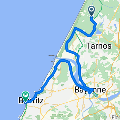
613 Chemin de Piron, Ondres naar 137 Route de Beyres, Ondres
A cycling route starting in Ondres, Aquitaine-Limousin-Poitou-Charentes, France.
Overview
About this route
- 2 h 53 min
- Duration
- 66.4 km
- Distance
- 244 m
- Ascent
- 248 m
- Descent
- 23 km/h
- Avg. speed
- 37 m
- Max. altitude

Route quality
Waytypes & surfaces along the route
Waytypes
Cycleway
21.7 km
(33 %)
Road
17.5 km
(26 %)
Surfaces
Paved
46.9 km
(71 %)
Unpaved
0.1 km
(<1 %)
Asphalt
46.7 km
(70 %)
Unpaved (undefined)
0.1 km
(<1 %)
Continue with Bikemap
Use, edit, or download this cycling route
You would like to ride 613 Chemin de Piron, Ondres naar 137 Route de Beyres, Ondres or customize it for your own trip? Here is what you can do with this Bikemap route:
Free features
- Save this route as favorite or in collections
- Copy & plan your own version of this route
- Sync your route with Garmin or Wahoo
Premium features
Free trial for 3 days, or one-time payment. More about Bikemap Premium.
- Navigate this route on iOS & Android
- Export a GPX / KML file of this route
- Create your custom printout (try it for free)
- Download this route for offline navigation
Discover more Premium features.
Get Bikemap PremiumFrom our community
Other popular routes starting in Ondres
 Itinéraire à partir de 35A Avenue du Docteur Louis Lesca, Ondres
- Distance
- 4 km
- Ascent
- 7 m
- Descent
- 44 m
- Location
- Ondres, Aquitaine-Limousin-Poitou-Charentes, France
 6 Ondres - Villafranca (Camping) 200 km
- Distance
- 199.9 km
- Ascent
- 1,346 m
- Descent
- 1,091 m
- Location
- Ondres, Aquitaine-Limousin-Poitou-Charentes, France
 Ondres - Biaritz
- Distance
- 28.1 km
- Ascent
- 89 m
- Descent
- 77 m
- Location
- Ondres, Aquitaine-Limousin-Poitou-Charentes, France
 Hardy Souston
- Distance
- 68.4 km
- Ascent
- 394 m
- Descent
- 393 m
- Location
- Ondres, Aquitaine-Limousin-Poitou-Charentes, France
 2 Velodyssee
- Distance
- 92.1 km
- Ascent
- 175 m
- Descent
- 194 m
- Location
- Ondres, Aquitaine-Limousin-Poitou-Charentes, France
 #25 Into Biarritz
- Distance
- 19.7 km
- Ascent
- 103 m
- Descent
- 92 m
- Location
- Ondres, Aquitaine-Limousin-Poitou-Charentes, France
 adour
adour- Distance
- 60.7 km
- Ascent
- 322 m
- Descent
- 321 m
- Location
- Ondres, Aquitaine-Limousin-Poitou-Charentes, France
 De Place Richard Feuillet 2, Ondres à Rue Georges Lafont 60, Ondres
- Distance
- 1.8 km
- Ascent
- 3 m
- Descent
- 75 m
- Location
- Ondres, Aquitaine-Limousin-Poitou-Charentes, France
Open it in the app