St. Jakob 3
A cycling route starting in Griffen, Carinthia, Austria.
Overview
About this route
St. Jakob - Ruden - Grutschn - St. paul - Lavamünd - Neuhaus - Schwabegg - Bleiburg - St. Michael - Sonneggersee - Sittersdorf - Müllnern - Rückersdorf - St. Primus - Unternarrach - Klopeinersee
- -:--
- Duration
- 76.2 km
- Distance
- 600 m
- Ascent
- 680 m
- Descent
- ---
- Avg. speed
- ---
- Max. altitude
Route quality
Waytypes & surfaces along the route
Waytypes
Busy road
50.3 km
(66 %)
Road
13.4 km
(18 %)
Surfaces
Paved
20.1 km
(26 %)
Asphalt
19 km
(25 %)
Paved (undefined)
0.9 km
(1 %)
Continue with Bikemap
Use, edit, or download this cycling route
You would like to ride St. Jakob 3 or customize it for your own trip? Here is what you can do with this Bikemap route:
Free features
- Save this route as favorite or in collections
- Copy & plan your own version of this route
- Sync your route with Garmin or Wahoo
Premium features
Free trial for 3 days, or one-time payment. More about Bikemap Premium.
- Navigate this route on iOS & Android
- Export a GPX / KML file of this route
- Create your custom printout (try it for free)
- Download this route for offline navigation
Discover more Premium features.
Get Bikemap PremiumFrom our community
Other popular routes starting in Griffen
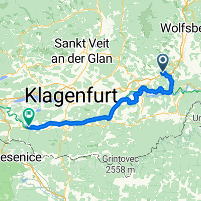
- Mur12a_Griffin_MariaElend_78,2km 480hm
- Distance
- 78.2 km
- Ascent
- 330 m
- Descent
- 323 m
- Location
- Griffen, Carinthia, Austria
- MTB-Around Griffen große Runde
- Distance
- 3 km
- Ascent
- 130 m
- Descent
- 128 m
- Location
- Griffen, Carinthia, Austria
- Griffen/Kolnitzgraben/Pustritz
- Distance
- 34.9 km
- Ascent
- 814 m
- Descent
- 814 m
- Location
- Griffen, Carinthia, Austria
- St. Jakob, Guttaring, retour
- Distance
- 83.6 km
- Ascent
- 489 m
- Descent
- 489 m
- Location
- Griffen, Carinthia, Austria
- Grenze
- Distance
- 44.2 km
- Ascent
- 228 m
- Descent
- 227 m
- Location
- Griffen, Carinthia, Austria
- Rund um Griffen
- Distance
- 26 km
- Ascent
- 525 m
- Descent
- 520 m
- Location
- Griffen, Carinthia, Austria
- 06.06.10 - Saualmpanoramarunde - Griffen - Diex CLONED FROM ROUTE 530385
- Distance
- 82.6 km
- Ascent
- 1,250 m
- Descent
- 1,250 m
- Location
- Griffen, Carinthia, Austria
- Pöllingerhütte
- Distance
- 22.8 km
- Ascent
- 1,227 m
- Descent
- 92 m
- Location
- Griffen, Carinthia, Austria
Open it in the app