

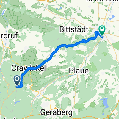
Illmenau - Schweinfurt
A cycling route starting in Frankenhain, Thuringia, Germany.
Overview
About this route
Illmenau nach Schweinfurt mit dem Tandem
- -:--
- Duration
- 116.5 km
- Distance
- 927 m
- Ascent
- 1,156 m
- Descent
- ---
- Avg. speed
- ---
- Max. altitude

Route quality
Waytypes & surfaces along the route
Waytypes
Path
8.2 km
(7 %)
Road
7 km
(6 %)
Surfaces
Paved
79.3 km
(68 %)
Unpaved
5.8 km
(5 %)
Asphalt
76.9 km
(66 %)
Ground
4.7 km
(4 %)
Continue with Bikemap
Use, edit, or download this cycling route
You would like to ride Illmenau - Schweinfurt or customize it for your own trip? Here is what you can do with this Bikemap route:
Free features
- Save this route as favorite or in collections
- Copy & plan your own version of this route
- Split it into stages to create a multi-day tour
- Sync your route with Garmin or Wahoo
Premium features
Free trial for 3 days, or one-time payment. More about Bikemap Premium.
- Navigate this route on iOS & Android
- Export a GPX / KML file of this route
- Create your custom printout (try it for free)
- Download this route for offline navigation
Discover more Premium features.
Get Bikemap PremiumFrom our community
Other popular routes starting in Frankenhain
 Illmenau - Schweinfurt
- Distance
- 116.5 km
- Ascent
- 927 m
- Descent
- 1,156 m
- Location
- Frankenhain, Thuringia, Germany
 Camping-Oberhof-Camping
- Distance
- 20.1 km
- Ascent
- 330 m
- Descent
- 330 m
- Location
- Frankenhain, Thuringia, Germany
 wegscheide-ohratalsperre-oberhof-wegscheide
- Distance
- 25.8 km
- Ascent
- 504 m
- Descent
- 504 m
- Location
- Frankenhain, Thuringia, Germany
 Geratal nach Oberhof
- Distance
- 3 km
- Ascent
- 122 m
- Descent
- 15 m
- Location
- Frankenhain, Thuringia, Germany
 Strongdog Ultratrail 2018 50km
- Distance
- 49.5 km
- Ascent
- 1,107 m
- Descent
- 1,102 m
- Location
- Frankenhain, Thuringia, Germany
 Camping-Gräfenroda-Frankenhain-Camping
- Distance
- 13.2 km
- Ascent
- 289 m
- Descent
- 289 m
- Location
- Frankenhain, Thuringia, Germany
 "kleine Runde" Teil 3
- Distance
- 20 km
- Ascent
- 42 m
- Descent
- 464 m
- Location
- Frankenhain, Thuringia, Germany
 Über Suhler Ausspanne
- Distance
- 22.5 km
- Ascent
- 452 m
- Descent
- 717 m
- Location
- Frankenhain, Thuringia, Germany
Open it in the app