

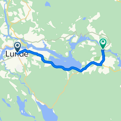
Lunde til Vrangfoss
A cycling route starting in Lunde, Telemark, Norway.
Overview
About this route
- -:--
- Duration
- 7.6 km
- Distance
- 83 m
- Ascent
- 114 m
- Descent
- ---
- Avg. speed
- 101 m
- Max. altitude

Route quality
Waytypes & surfaces along the route
Waytypes
Quiet road
0.3 km
(4 %)
Access road
0.2 km
(2 %)
Undefined
7.2 km
(94 %)
Surfaces
Paved
7.3 km
(96 %)
Asphalt
7.3 km
(96 %)
Undefined
0.3 km
(4 %)
Continue with Bikemap
Use, edit, or download this cycling route
You would like to ride Lunde til Vrangfoss or customize it for your own trip? Here is what you can do with this Bikemap route:
Free features
- Save this route as favorite or in collections
- Copy & plan your own version of this route
- Sync your route with Garmin or Wahoo
Premium features
Free trial for 3 days, or one-time payment. More about Bikemap Premium.
- Navigate this route on iOS & Android
- Export a GPX / KML file of this route
- Create your custom printout (try it for free)
- Download this route for offline navigation
Discover more Premium features.
Get Bikemap PremiumFrom our community
Other popular routes starting in Lunde
 Lunde til Vrangfoss
- Distance
- 7.6 km
- Ascent
- 83 m
- Descent
- 114 m
- Location
- Lunde, Telemark, Norway
 Nome
Nome- Distance
- 13.5 km
- Ascent
- 195 m
- Descent
- 254 m
- Location
- Lunde, Telemark, Norway
 "Motbakken"
- Distance
- 60.8 km
- Ascent
- 841 m
- Descent
- 841 m
- Location
- Lunde, Telemark, Norway
 Telemarkskanal og setesdal 2020
- Distance
- 326.7 km
- Ascent
- 1,274 m
- Descent
- 1,338 m
- Location
- Lunde, Telemark, Norway
 Lunde-Spjotsodd
- Distance
- 48.1 km
- Ascent
- 422 m
- Descent
- 418 m
- Location
- Lunde, Telemark, Norway
 Lunde rundtur
- Distance
- 34.4 km
- Ascent
- 434 m
- Descent
- 432 m
- Location
- Lunde, Telemark, Norway
 04 Lunde - Strond
- Distance
- 52.8 km
- Ascent
- 1,176 m
- Descent
- 984 m
- Location
- Lunde, Telemark, Norway
 Telemarkskanalen Lunde-Dalen
- Distance
- 99.2 km
- Ascent
- 2,145 m
- Descent
- 2,182 m
- Location
- Lunde, Telemark, Norway
Open it in the app