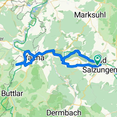
vom Bahnhof Bad Salzungen über den Pumpälzweg nach Eisenach zum Bahnhof
A cycling route starting in Bad Salzungen, Free State of Thuringia, Germany.
Overview
About this route
Über Barchfeld und die Marientaler Höhe trifft man bei der Auffahrt zum Waldgasthaus "Kissel" auf den "richtigen" Pumpälzweg. Ab dort wird der Weg viele lose Steine!
Auch an der Kreuzung der Route mit der Ortsverbindungsstraße Etterwinden - Ruhla gibt es noch ein Gasthaus.
An Eisenach faährt man problemlos mit der Südthüringenbahn (mit dem Rad im Zug!) zurück.
- -:--
- Duration
- 31.9 km
- Distance
- 572 m
- Ascent
- 599 m
- Descent
- ---
- Avg. speed
- ---
- Avg. speed
Continue with Bikemap
Use, edit, or download this cycling route
You would like to ride vom Bahnhof Bad Salzungen über den Pumpälzweg nach Eisenach zum Bahnhof or customize it for your own trip? Here is what you can do with this Bikemap route:
Free features
- Save this route as favorite or in collections
- Copy & plan your own version of this route
- Sync your route with Garmin or Wahoo
Premium features
Free trial for 3 days, or one-time payment. More about Bikemap Premium.
- Navigate this route on iOS & Android
- Export a GPX / KML file of this route
- Create your custom printout (try it for free)
- Download this route for offline navigation
Discover more Premium features.
Get Bikemap PremiumFrom our community
Other popular routes starting in Bad Salzungen
- 13.07.24 Bad Salzungen-Hörschel
- Distance
- 79.9 km
- Ascent
- 289 m
- Descent
- 331 m
- Location
- Bad Salzungen, Free State of Thuringia, Germany
- Bad Salzungen Inselsberg und zurück
- Distance
- 56.9 km
- Ascent
- 937 m
- Descent
- 937 m
- Location
- Bad Salzungen, Free State of Thuringia, Germany
- Bad-Salzungen nach Oberhof
- Distance
- 80.5 km
- Ascent
- 1,155 m
- Descent
- 625 m
- Location
- Bad Salzungen, Free State of Thuringia, Germany
- Bad Salzungen // Walnusshof; Langenfelder Str. 2 nach Tropfsteinhöhle Kittelsthal und zurück
- Distance
- 51.4 km
- Ascent
- 823 m
- Descent
- 822 m
- Location
- Bad Salzungen, Free State of Thuringia, Germany
- BaSa - U-Bach - BaSa
- Distance
- 52.5 km
- Ascent
- 442 m
- Descent
- 441 m
- Location
- Bad Salzungen, Free State of Thuringia, Germany
- Pleßrunde
- Distance
- 34.5 km
- Ascent
- 450 m
- Descent
- 452 m
- Location
- Bad Salzungen, Free State of Thuringia, Germany
- Pleßenduro
- Distance
- 36.3 km
- Ascent
- 910 m
- Descent
- 910 m
- Location
- Bad Salzungen, Free State of Thuringia, Germany
- Moorgrundrunde
- Distance
- 31.8 km
- Ascent
- 337 m
- Descent
- 337 m
- Location
- Bad Salzungen, Free State of Thuringia, Germany
Open it in the app