Schiesseralm Trail / Frani Haustrail
A cycling route starting in Rettenschöss, Tyrol, Austria.
Overview
About this route
Traum Uphill mit Ausblick in das Inntal und Kaisergebirge - Netter Trail mit teils flowigen teils leicht technischen Passagen - perfekte Abendrunde
- -:--
- Duration
- 12.9 km
- Distance
- 595 m
- Ascent
- 597 m
- Descent
- ---
- Avg. speed
- ---
- Avg. speed
Continue with Bikemap
Use, edit, or download this cycling route
You would like to ride Schiesseralm Trail / Frani Haustrail or customize it for your own trip? Here is what you can do with this Bikemap route:
Free features
- Save this route as favorite or in collections
- Copy & plan your own version of this route
- Sync your route with Garmin or Wahoo
Premium features
Free trial for 3 days, or one-time payment. More about Bikemap Premium.
- Navigate this route on iOS & Android
- Export a GPX / KML file of this route
- Create your custom printout (try it for free)
- Download this route for offline navigation
Discover more Premium features.
Get Bikemap PremiumFrom our community
Other popular routes starting in Rettenschöss
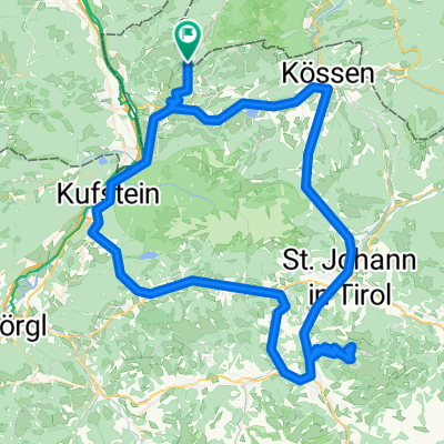
- ride from Rettenschöss to Walchsee
- Distance
- 14.2 km
- Ascent
- 205 m
- Descent
- 546 m
- Location
- Rettenschöss, Tyrol, Austria
- Aschau - Wildbichalalm - Wandberghütte
- Distance
- 7.2 km
- Ascent
- 706 m
- Descent
- 98 m
- Location
- Rettenschöss, Tyrol, Austria
- 14 - Durcholzen-Kössen-Durchholzen
- Distance
- 24.8 km
- Ascent
- 258 m
- Descent
- 256 m
- Location
- Rettenschöss, Tyrol, Austria
- Kasalm
- Distance
- 24.4 km
- Ascent
- 885 m
- Descent
- 885 m
- Location
- Rettenschöss, Tyrol, Austria
- Buchberg - Walchsee
- Distance
- 31.7 km
- Ascent
- 355 m
- Descent
- 350 m
- Location
- Rettenschöss, Tyrol, Austria
- Kitzbühler Horn
- Distance
- 121.7 km
- Ascent
- 2,159 m
- Descent
- 2,159 m
- Location
- Rettenschöss, Tyrol, Austria
- Tour de Wandberg - Auffahrt
- Distance
- 10.7 km
- Ascent
- 919 m
- Descent
- 127 m
- Location
- Rettenschöss, Tyrol, Austria
- Schiesseralm Trail / Frani Haustrail
- Distance
- 12.9 km
- Ascent
- 595 m
- Descent
- 597 m
- Location
- Rettenschöss, Tyrol, Austria
Open it in the app