

AK-05 nap Őr - Nyíradony
A cycling route starting in Vaja, Szabolcs-Szatmár-Bereg, Hungary.
Overview
About this route
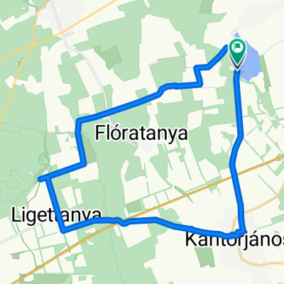
AK-05 nap Őr - Nyíradony
- -:--
- Duration
- 76.2 km
- Distance
- 203 m
- Ascent
- 193 m
- Descent
- ---
- Avg. speed
- 168 m
- Max. altitude

Route quality
Waytypes & surfaces along the route
Waytypes
Quiet road
13 km
(17 %)
Road
9.1 km
(12 %)
Surfaces
Paved
16 km
(21 %)
Asphalt
16 km
(21 %)
Undefined
60.2 km
(79 %)
Continue with Bikemap
Use, edit, or download this cycling route
You would like to ride AK-05 nap Őr - Nyíradony or customize it for your own trip? Here is what you can do with this Bikemap route:
Free features
- Save this route as favorite or in collections
- Copy & plan your own version of this route
- Sync your route with Garmin or Wahoo
Premium features
Free trial for 3 days, or one-time payment. More about Bikemap Premium.
- Navigate this route on iOS & Android
- Export a GPX / KML file of this route
- Create your custom printout (try it for free)
- Download this route for offline navigation
Discover more Premium features.
Get Bikemap PremiumFrom our community
Other popular routes starting in Vaja
 Névtelen Út - Névtelen Út
- Distance
- 20.8 km
- Ascent
- 53 m
- Descent
- 53 m
- Location
- Vaja, Szabolcs-Szatmár-Bereg, Hungary
 AK-05 nap Őr - Nyíradony
- Distance
- 76.2 km
- Ascent
- 203 m
- Descent
- 193 m
- Location
- Vaja, Szabolcs-Szatmár-Bereg, Hungary
 Easy ride in Rohod
- Distance
- 19.2 km
- Ascent
- 91 m
- Descent
- 89 m
- Location
- Vaja, Szabolcs-Szatmár-Bereg, Hungary
Open it in the app