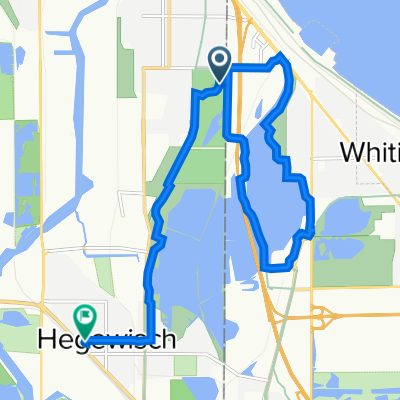
Recovered Route
A cycling route starting in Whiting, Indiana, United States of America.
Overview
About this route
- 58 min
- Duration
- 19.1 km
- Distance
- 46 m
- Ascent
- 43 m
- Descent
- 19.6 km/h
- Avg. speed
- 189 m
- Max. altitude
Route quality
Waytypes & surfaces along the route
Waytypes
Cycleway
17.1 km
(90 %)
Pedestrian area
2 km
(10 %)
Surfaces
Paved
17.5 km
(92 %)
Asphalt
13.8 km
(72 %)
Concrete
3.1 km
(16 %)
Continue with Bikemap
Use, edit, or download this cycling route
You would like to ride Recovered Route or customize it for your own trip? Here is what you can do with this Bikemap route:
Free features
- Save this route as favorite or in collections
- Copy & plan your own version of this route
- Sync your route with Garmin or Wahoo
Premium features
Free trial for 3 days, or one-time payment. More about Bikemap Premium.
- Navigate this route on iOS & Android
- Export a GPX / KML file of this route
- Create your custom printout (try it for free)
- Download this route for offline navigation
Discover more Premium features.
Get Bikemap PremiumFrom our community
Other popular routes starting in Whiting
- East 98th Street 4001, Chicago to South Saginaw Avenue 8823, Chicago
- Distance
- 4.8 km
- Ascent
- 74 m
- Descent
- 76 m
- Location
- Whiting, Indiana, United States of America
- South to North and back
- Distance
- 53.9 km
- Ascent
- 54 m
- Descent
- 34 m
- Location
- Whiting, Indiana, United States of America
- Moderate route in Hammond
- Distance
- 10.2 km
- Ascent
- 12 m
- Descent
- 8 m
- Location
- Whiting, Indiana, United States of America
- 10839 S Avenue B, Chicago to Lakefront Trail, Chicago
- Distance
- 15.5 km
- Ascent
- 431 m
- Descent
- 431 m
- Location
- Whiting, Indiana, United States of America
- 2227 New York Ave, Hammond to 1741 Atchison Ave, Whiting
- Distance
- 13.3 km
- Ascent
- 10 m
- Descent
- 12 m
- Location
- Whiting, Indiana, United States of America
- Calumet Avenue 2600, Hammond to Calumet Avenue 2600, Hammond
- Distance
- 12.5 km
- Ascent
- 50 m
- Descent
- 20 m
- Location
- Whiting, Indiana, United States of America
- South Saginaw Avenue 8823, Chicago to South Saginaw Avenue 8823, Chicago
- Distance
- 4.1 km
- Ascent
- 3 m
- Descent
- 3 m
- Location
- Whiting, Indiana, United States of America
- Indiana State Line
- Distance
- 13.4 km
- Ascent
- 33 m
- Descent
- 31 m
- Location
- Whiting, Indiana, United States of America
Open it in the app