

Piste cyclable Châteauguay
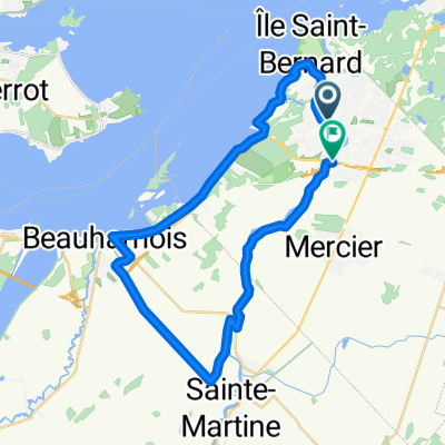
A cycling route starting in Châteauguay, Quebec, Canada.
Overview
About this route
Été 2011
Attention, travaux sur la rue Bellevue à Léry.
Chemin très difficile.
Aussi travaux important sur le Chemin Lac Saint Louis. Impossible de passer, détour par la 132.
- -:--
- Duration
- 22 km
- Distance
- 36 m
- Ascent
- 32 m
- Descent
- ---
- Avg. speed
- ---
- Max. altitude
Route quality
Waytypes & surfaces along the route
Waytypes
Quiet road
11.4 km
(52 %)
Road
10.5 km
(48 %)
Surfaces
Paved
21.3 km
(97 %)
Asphalt
18.5 km
(84 %)
Paved (undefined)
2.8 km
(13 %)
Undefined
0.7 km
(3 %)
Continue with Bikemap
Use, edit, or download this cycling route
You would like to ride Piste cyclable Châteauguay or customize it for your own trip? Here is what you can do with this Bikemap route:
Free features
- Save this route as favorite or in collections
- Copy & plan your own version of this route
- Sync your route with Garmin or Wahoo
Premium features
Free trial for 3 days, or one-time payment. More about Bikemap Premium.
- Navigate this route on iOS & Android
- Export a GPX / KML file of this route
- Create your custom printout (try it for free)
- Download this route for offline navigation
Discover more Premium features.
Get Bikemap PremiumFrom our community
Other popular routes starting in Châteauguay
 Chateauguay-Ormstown 109km
- Distance
- 109.9 km
- Ascent
- 49 m
- Descent
- 47 m
- Location
- Châteauguay, Quebec, Canada
 132 Rue Henriette-Caron, Châteauguay to 169 Rue Principale, Saint-Louis-de-Gonzague
- Distance
- 31.1 km
- Ascent
- 10 m
- Descent
- 0 m
- Location
- Châteauguay, Quebec, Canada
 Boucle lac st-louis-beauharnois-ste-martine 3 septembre 08:28
- Distance
- 41.3 km
- Ascent
- 35 m
- Descent
- 23 m
- Location
- Châteauguay, Quebec, Canada
 Boulevard D'Youville 5, Châteauguay to Rue des Sittelles 200, Châteauguay
- Distance
- 38.7 km
- Ascent
- 170 m
- Descent
- 172 m
- Location
- Châteauguay, Quebec, Canada
 Itinéraire vers 500 Boul d'Youville, Châteauguay
- Distance
- 41.7 km
- Ascent
- 83 m
- Descent
- 88 m
- Location
- Châteauguay, Quebec, Canada
 ced route 2
- Distance
- 39.9 km
- Ascent
- 51 m
- Descent
- 51 m
- Location
- Châteauguay, Quebec, Canada
 Chateaugay-St-Louis de Gonzague-Beauharnois
- Distance
- 75.7 km
- Ascent
- 51 m
- Descent
- 51 m
- Location
- Châteauguay, Quebec, Canada
 Club Vélo Sélect 2009
- Distance
- 199.2 km
- Ascent
- 572 m
- Descent
- 571 m
- Location
- Châteauguay, Quebec, Canada
Open it in the app