
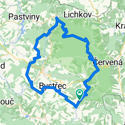
přes Suchý vrch
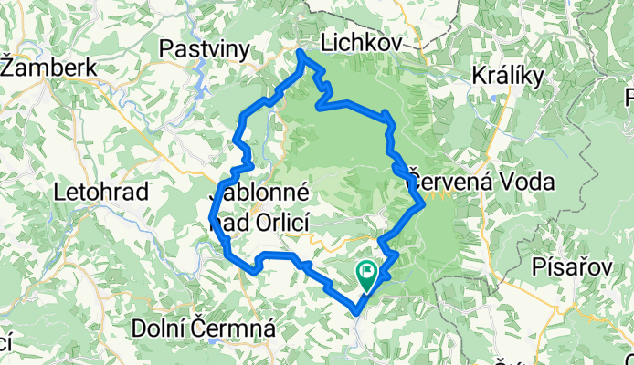
A cycling route starting in Bystřec, Pardubický kraj, Czechia.
Overview
About this route
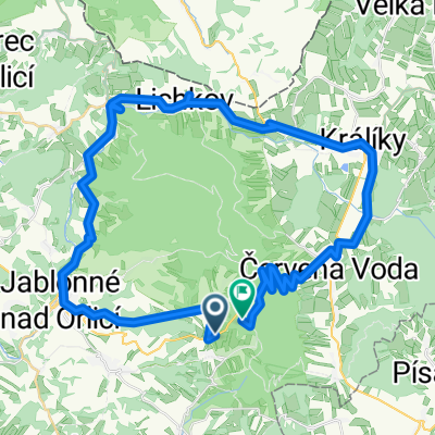
Výprachtice - Čenkovice - Suchý vrch - Mladkov - Sobkovice - Mistrovice - Bystřec - Výprachtice
- -:--
- Duration
- 44 km
- Distance
- 814 m
- Ascent
- 814 m
- Descent
- ---
- Avg. speed
- ---
- Max. altitude
Route quality
Waytypes & surfaces along the route
Waytypes
Road
21.1 km
(48 %)
Track
10.6 km
(24 %)
Surfaces
Paved
18.5 km
(42 %)
Unpaved
7.9 km
(18 %)
Asphalt
16.7 km
(38 %)
Gravel
4.4 km
(10 %)
Route highlights
Points of interest along the route
Point of interest after 10.1 km
Rozhledna Suchý vrch
Point of interest after 12.9 km
Dělostřelecká tvrz Bouda
Point of interest after 18.9 km
Pramen kníž. Rostislava
Point of interest after 27 km
daleký rozhled do okolí
Continue with Bikemap
Use, edit, or download this cycling route
You would like to ride přes Suchý vrch or customize it for your own trip? Here is what you can do with this Bikemap route:
Free features
- Save this route as favorite or in collections
- Copy & plan your own version of this route
- Sync your route with Garmin or Wahoo
Premium features
Free trial for 3 days, or one-time payment. More about Bikemap Premium.
- Navigate this route on iOS & Android
- Export a GPX / KML file of this route
- Create your custom printout (try it for free)
- Download this route for offline navigation
Discover more Premium features.
Get Bikemap PremiumFrom our community
Other popular routes starting in Bystřec
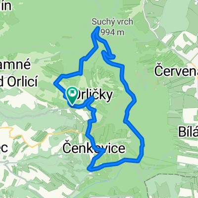 Orličky - Čenkovice - Buková hora - Suchý vrch - Orličky
- Distance
- 20 km
- Ascent
- 591 m
- Descent
- 591 m
- Location
- Bystřec, Pardubický kraj, Czechia
 Bystřec - Mladkov - Rokytnice - Orlické Záhoří a zpět
- Distance
- 97.6 km
- Ascent
- 1,329 m
- Descent
- 1,339 m
- Location
- Bystřec, Pardubický kraj, Czechia
 Bystřec/Lanškroun//stí/Česká Tř/Lanškroun/Bystřec
- Distance
- 71 km
- Ascent
- 1,018 m
- Descent
- 1,048 m
- Location
- Bystřec, Pardubický kraj, Czechia
 Bystřec - Suchý vrch - Dlouhé stráně a zpět
- Distance
- 175.9 km
- Ascent
- 2,559 m
- Descent
- 2,559 m
- Location
- Bystřec, Pardubický kraj, Czechia
 přes Suchý vrch
- Distance
- 44 km
- Ascent
- 814 m
- Descent
- 814 m
- Location
- Bystřec, Pardubický kraj, Czechia
 Tři hrby
- Distance
- 57.5 km
- Ascent
- 1,203 m
- Descent
- 1,207 m
- Location
- Bystřec, Pardubický kraj, Czechia
 Čenkovice-Valterice-Stity-Cotkytle-Hermanice-Jablonne-Cenkovice
- Distance
- 53.7 km
- Ascent
- 1,340 m
- Descent
- 1,319 m
- Location
- Bystřec, Pardubický kraj, Czechia
 Suchák
- Distance
- 45.2 km
- Ascent
- 660 m
- Descent
- 532 m
- Location
- Bystřec, Pardubický kraj, Czechia
Open it in the app