Salers Puy Mary Salers
A cycling route starting in Saint-Cernin, Auvergne-Rh么ne-Alpes, France.
Overview
About this route
- -:--
- Duration
- 69.2 km
- Distance
- 1,338 m
- Ascent
- 1,338 m
- Descent
- ---
- Avg. speed
- ---
- Avg. speed
Route quality
Waytypes & surfaces along the route
Waytypes
Busy road
36.9 km
(53 %)
Road
30.8 km
(44 %)
Surfaces
Paved
32.2 km
(46 %)
Unpaved
1.3 km
(2 %)
Asphalt
32.2 km
(46 %)
Ground
1.2 km
(2 %)
Continue with Bikemap
Use, edit, or download this cycling route
You would like to ride Salers Puy Mary Salers or customize it for your own trip? Here is what you can do with this Bikemap route:
Free features
- Save this route as favorite or in collections
- Copy & plan your own version of this route
- Sync your route with Garmin or Wahoo
Premium features
Free trial for 3 days, or one-time payment. More about Bikemap Premium.
- Navigate this route on iOS & Android
- Export a GPX / KML file of this route
- Create your custom printout (try it for free)
- Download this route for offline navigation
Discover more Premium features.
Get Bikemap PremiumFrom our community
Other popular routes starting in Saint-Cernin
- cantal tour (2)
- Distance
- 270.9 km
- Ascent
- 2,997 m
- Descent
- 3,015 m
- Location
- Saint-Cernin, Auvergne-Rh么ne-Alpes, France
- Salers-Puy Mary-Salers
- Distance
- 62.8 km
- Ascent
- 1,396 m
- Descent
- 1,392 m
- Location
- Saint-Cernin, Auvergne-Rh么ne-Alpes, France
- L脡GAL, por Saint Georges
- Distance
- 5.7 km
- Ascent
- 468 m
- Descent
- 159 m
- Location
- Saint-Cernin, Auvergne-Rh么ne-Alpes, France
- les trois cols du cantal
- Distance
- 75.8 km
- Ascent
- 1,452 m
- Descent
- 1,452 m
- Location
- Saint-Cernin, Auvergne-Rh么ne-Alpes, France
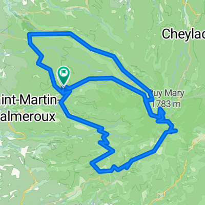
- Salers - Saint-Jacques-des-Blats
- Distance
- 43.4 km
- Ascent
- 1,042 m
- Descent
- 1,052 m
- Location
- Saint-Cernin, Auvergne-Rh么ne-Alpes, France
- Cantal 2022 N掳5 133kms 2500D+
- Distance
- 132.7 km
- Ascent
- 2,871 m
- Descent
- 2,873 m
- Location
- Saint-Cernin, Auvergne-Rh么ne-Alpes, France
- SAINT GEORGES, por Fontagnes
- Distance
- 6.9 km
- Ascent
- 285 m
- Descent
- 57 m
- Location
- Saint-Cernin, Auvergne-Rh么ne-Alpes, France
- Gerade Fahrt in Aurillac
- Distance
- 30.7 km
- Ascent
- 399 m
- Descent
- 533 m
- Location
- Saint-Cernin, Auvergne-Rh么ne-Alpes, France
Open it in the app