
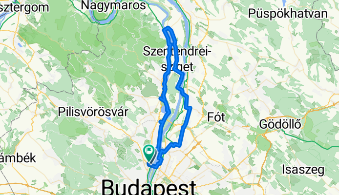
Óbuda-Tahitótfalu-Dunakeszi-Óbuda kerékpár túra útvonal, kipróbált helyekkel, ahol enni és inni lehet
A cycling route starting in Óbuda-Békásmegyer, Budapest, Hungary.
Overview
About this route
- -:--
- Duration
- 66.1 km
- Distance
- 53 m
- Ascent
- 50 m
- Descent
- ---
- Avg. speed
- ---
- Max. altitude
Route quality
Waytypes & surfaces along the route
Waytypes
Quiet road
17.1 km
(26 %)
Cycleway
16.7 km
(25 %)
Surfaces
Paved
46.3 km
(70 %)
Unpaved
6 km
(9 %)
Asphalt
43.1 km
(65 %)
Gravel
3.8 km
(6 %)
Route highlights
Points of interest along the route
Point of interest after 1 km
Point of interest after 52.4 km
Ha ki akarod hagyni Újpestet, itt kanyarodhatsz jobbra a Megyeri híd felé
Point of interest after 63.8 km
Continue with Bikemap
Use, edit, or download this cycling route
You would like to ride Óbuda-Tahitótfalu-Dunakeszi-Óbuda kerékpár túra útvonal, kipróbált helyekkel, ahol enni és inni lehet or customize it for your own trip? Here is what you can do with this Bikemap route:
Free features
- Save this route as favorite or in collections
- Copy & plan your own version of this route
- Sync your route with Garmin or Wahoo
Premium features
Free trial for 3 days, or one-time payment. More about Bikemap Premium.
- Navigate this route on iOS & Android
- Export a GPX / KML file of this route
- Create your custom printout (try it for free)
- Download this route for offline navigation
Discover more Premium features.
Get Bikemap PremiumFrom our community
Other popular routes starting in Óbuda-Békásmegyer
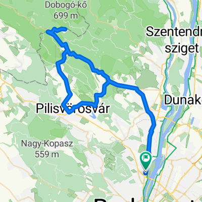
 Alternatív rövid könnyű útvonal
- Distance
- 34.1 km
- Ascent
- 211 m
- Descent
- 207 m
- Location
- Óbuda-Békásmegyer, Budapest, Hungary
 Coffee Ride - Csobánka Szántó Dobogókő
- Distance
- 74.3 km
- Ascent
- 716 m
- Descent
- 720 m
- Location
- Óbuda-Békásmegyer, Budapest, Hungary
 Vihar utca, Budapest to Őrlő utca, Budapest
- Distance
- 13 km
- Ascent
- 117 m
- Descent
- 119 m
- Location
- Óbuda-Békásmegyer, Budapest, Hungary
 CR | Dömörkapu - Dobogókő
- Distance
- 74.4 km
- Ascent
- 740 m
- Descent
- 741 m
- Location
- Óbuda-Békásmegyer, Budapest, Hungary
 Teca kocsmája a hegyen át
- Distance
- 101.4 km
- Ascent
- 803 m
- Descent
- 803 m
- Location
- Óbuda-Békásmegyer, Budapest, Hungary
 CoffeeRide - Kisoroszi
- Distance
- 72.4 km
- Ascent
- 68 m
- Descent
- 67 m
- Location
- Óbuda-Békásmegyer, Budapest, Hungary
 CR - Skanzen kör
- Distance
- 44.8 km
- Ascent
- 169 m
- Descent
- 166 m
- Location
- Óbuda-Békásmegyer, Budapest, Hungary
 HHH gyors
- Distance
- 16 km
- Ascent
- 477 m
- Descent
- 477 m
- Location
- Óbuda-Békásmegyer, Budapest, Hungary
Open it in the app