
Auf den Spuren der Wölfe
A cycling route starting in Weißwasser, Saxony, Germany.
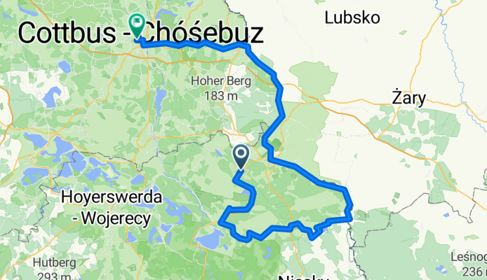
Overview
About this route
Weisswasser >Wolfs-Radweg >Schloss Niederspree >Bad Muskau >Forst
- -:--
- Duration
- 146.7 km
- Distance
- 146 m
- Ascent
- 206 m
- Descent
- ---
- Avg. speed
- ---
- Max. altitude
Route highlights
Points of interest along the route
Point of interest after 15.7 km
Findlingspark
Continue with Bikemap
Use, edit, or download this cycling route
You would like to ride Auf den Spuren der Wölfe or customize it for your own trip? Here is what you can do with this Bikemap route:
Free features
- Save this route as favorite or in collections
- Copy & plan your own version of this route
- Split it into stages to create a multi-day tour
- Sync your route with Garmin or Wahoo
Premium features
Free trial for 3 days, or one-time payment. More about Bikemap Premium.
- Navigate this route on iOS & Android
- Export a GPX / KML file of this route
- Create your custom printout (try it for free)
- Download this route for offline navigation
Discover more Premium features.
Get Bikemap PremiumFrom our community
Other popular routes starting in Weißwasser
 090728.WSW -DD erweitert
- Distance
- 126.9 km
- Ascent
- 306 m
- Descent
- 327 m
- Location
- Weißwasser, Saxony, Germany
 LK Görlitz - Rundfahrt
- Distance
- 279 km
- Ascent
- 1,481 m
- Descent
- 1,481 m
- Location
- Weißwasser, Saxony, Germany
 Schmiedestraße 1, Weißwasser/Oberlausitz do Schmiedestraße 1, Weißwasser/Oberlausitz
- Distance
- 72 km
- Ascent
- 237 m
- Descent
- 237 m
- Location
- Weißwasser, Saxony, Germany
 Hermannstraße, Weißwasser/Oberlausitz nach Geschwister-Scholl-Straße, Krauschwitz
- Distance
- 7.5 km
- Ascent
- 65 m
- Descent
- 86 m
- Location
- Weißwasser, Saxony, Germany
 WSW-Bad Muskau,Leknica,Krauschwitz-WSW
- Distance
- 29.2 km
- Ascent
- 104 m
- Descent
- 104 m
- Location
- Weißwasser, Saxony, Germany
 Himmelfahrt 2019
- Distance
- 44.8 km
- Ascent
- 71 m
- Descent
- 71 m
- Location
- Weißwasser, Saxony, Germany
 Herrentagstour 2017 Tag 1: Donnerstag,25.05.17 Cottbus - Weißwasser
- Distance
- 38.6 km
- Ascent
- 97 m
- Descent
- 175 m
- Location
- Weißwasser, Saxony, Germany
 Planung 42,195 Tagebau
- Distance
- 41.9 km
- Ascent
- 111 m
- Descent
- 121 m
- Location
- Weißwasser, Saxony, Germany
Open it in the app