

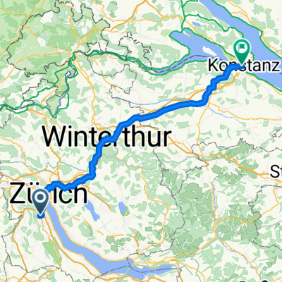
Zürich - Dauchingen - Beffendorf - Karlsruhe - StB
A cycling route starting in Zürich (Kreis 2) / Unter-Leimbach, Canton of Zurich, Switzerland.
Overview
About this route
PLanung Für Radtour Nico@Leimbach - StB in 3 Tagen
- -:--
- Duration
- 362.5 km
- Distance
- 3,528 m
- Ascent
- 3,851 m
- Descent
- ---
- Avg. speed
- 776 m
- Max. altitude

Route quality
Waytypes & surfaces along the route
Waytypes
Quiet road
94.9 km
(26 %)
Track
75.5 km
(21 %)
Surfaces
Paved
328.9 km
(91 %)
Unpaved
9.1 km
(2 %)
Asphalt
298.4 km
(82 %)
Paved (undefined)
15.6 km
(4 %)
Continue with Bikemap
Use, edit, or download this cycling route
You would like to ride Zürich - Dauchingen - Beffendorf - Karlsruhe - StB or customize it for your own trip? Here is what you can do with this Bikemap route:
Free features
- Save this route as favorite or in collections
- Copy & plan your own version of this route
- Split it into stages to create a multi-day tour
- Sync your route with Garmin or Wahoo
Premium features
Free trial for 3 days, or one-time payment. More about Bikemap Premium.
- Navigate this route on iOS & Android
- Export a GPX / KML file of this route
- Create your custom printout (try it for free)
- Download this route for offline navigation
Discover more Premium features.
Get Bikemap PremiumFrom our community
Other popular routes starting in Zürich (Kreis 2) / Unter-Leimbach
 19.7.13
- Distance
- 4.1 km
- Ascent
- 53 m
- Descent
- 48 m
- Location
- Zürich (Kreis 2) / Unter-Leimbach, Canton of Zurich, Switzerland
 Restful route in Zürich
- Distance
- 14.1 km
- Ascent
- 176 m
- Descent
- 186 m
- Location
- Zürich (Kreis 2) / Unter-Leimbach, Canton of Zurich, Switzerland
 Zürich - Dauchingen - Beffendorf - Karlsruhe - StB
- Distance
- 362.5 km
- Ascent
- 3,528 m
- Descent
- 3,851 m
- Location
- Zürich (Kreis 2) / Unter-Leimbach, Canton of Zurich, Switzerland
 Ankenweid 12, Zürich to Ankenweid 17, Zürich
- Distance
- 28.9 km
- Ascent
- 595 m
- Descent
- 595 m
- Location
- Zürich (Kreis 2) / Unter-Leimbach, Canton of Zurich, Switzerland
 Gratstrasse, Stallikon nach Naturfreundeweg 8, Langnau am Albis
- Distance
- 8.2 km
- Ascent
- 278 m
- Descent
- 229 m
- Location
- Zürich (Kreis 2) / Unter-Leimbach, Canton of Zurich, Switzerland
 Soodstrasse 14–46, Zürich to Sihlrainstrasse 16, Zürich
- Distance
- 31.1 km
- Ascent
- 506 m
- Descent
- 511 m
- Location
- Zürich (Kreis 2) / Unter-Leimbach, Canton of Zurich, Switzerland
 Zürich (Kreis 2) / Unter-Leimbach - Kreuzlingen
- Distance
- 81.6 km
- Ascent
- 948 m
- Descent
- 1,023 m
- Location
- Zürich (Kreis 2) / Unter-Leimbach, Canton of Zurich, Switzerland
 Ankenweid 10, Zürich to Ankenweid 17, Zürich
- Distance
- 14 km
- Ascent
- 142 m
- Descent
- 137 m
- Location
- Zürich (Kreis 2) / Unter-Leimbach, Canton of Zurich, Switzerland
Open it in the app