

GPX Download: Schattige Waldwege – Wunderschöne Aussicht Runde von Marienhafe - GPX Download: Schattige Waldwege – Wunderschöne Aussicht Runde von Marienhafe
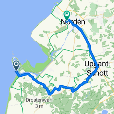
A cycling route starting in Marienhafe, Lower Saxony, Germany.
Overview
About this route
null
- -:--
- Duration
- 56.3 km
- Distance
- 28 m
- Ascent
- 29 m
- Descent
- ---
- Avg. speed
- 11 m
- Max. altitude

Route quality
Waytypes & surfaces along the route
Waytypes
Quiet road
25.9 km
(46 %)
Track
12.9 km
(23 %)
Surfaces
Paved
28.7 km
(51 %)
Asphalt
19.7 km
(35 %)
Paved (undefined)
7.9 km
(14 %)
Continue with Bikemap
Use, edit, or download this cycling route
You would like to ride GPX Download: Schattige Waldwege – Wunderschöne Aussicht Runde von Marienhafe - GPX Download: Schattige Waldwege – Wunderschöne Aussicht Runde von Marienhafe or customize it for your own trip? Here is what you can do with this Bikemap route:
Free features
- Save this route as favorite or in collections
- Copy & plan your own version of this route
- Sync your route with Garmin or Wahoo
Premium features
Free trial for 3 days, or one-time payment. More about Bikemap Premium.
- Navigate this route on iOS & Android
- Export a GPX / KML file of this route
- Create your custom printout (try it for free)
- Download this route for offline navigation
Discover more Premium features.
Get Bikemap PremiumFrom our community
Other popular routes starting in Marienhafe
 Greetsiel
- Distance
- 338.1 km
- Ascent
- 3,750 m
- Descent
- 3,758 m
- Location
- Marienhafe, Lower Saxony, Germany
 Windmühlen 55 km
- Distance
- 55.6 km
- Ascent
- 8 m
- Descent
- 8 m
- Location
- Marienhafe, Lower Saxony, Germany
 Langsame Fahrt in Marienhafe
- Distance
- 7.7 km
- Ascent
- 0 m
- Descent
- 0 m
- Location
- Marienhafe, Lower Saxony, Germany
 Tjücher Dreesche 13, Marienhafe nach Schatthauser Weg 2A, Krummhörn
- Distance
- 21.2 km
- Ascent
- 6 m
- Descent
- 7 m
- Location
- Marienhafe, Lower Saxony, Germany
 Marienhafe - Holtgast
- Distance
- 34 km
- Ascent
- 29 m
- Descent
- 29 m
- Location
- Marienhafe, Lower Saxony, Germany
 Geesthörn 15, Upgant-Schott nach Geesthörn 15, Upgant-Schott
- Distance
- 38.7 km
- Ascent
- 88 m
- Descent
- 90 m
- Location
- Marienhafe, Lower Saxony, Germany
 Osterupgant, Graf Enno Str. 3 (Rückweg)
- Distance
- 10.2 km
- Ascent
- 0 m
- Descent
- 0 m
- Location
- Marienhafe, Lower Saxony, Germany
 Gemütliche Route in Marienhafe
- Distance
- 9.2 km
- Ascent
- 16 m
- Descent
- 16 m
- Location
- Marienhafe, Lower Saxony, Germany
Open it in the app