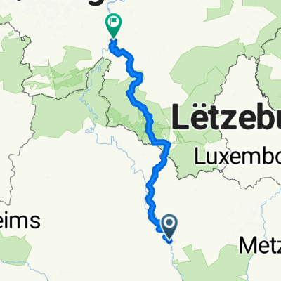
Verdun Bras
A cycling route starting in Verdun, Grand Est, France.
Overview
About this route
- 1 h 18 min
- Duration
- 15.8 km
- Distance
- 98 m
- Ascent
- 100 m
- Descent
- 12.1 km/h
- Avg. speed
- 214 m
- Max. altitude
Route photos
Continue with Bikemap
Use, edit, or download this cycling route
You would like to ride Verdun Bras or customize it for your own trip? Here is what you can do with this Bikemap route:
Free features
- Save this route as favorite or in collections
- Copy & plan your own version of this route
- Sync your route with Garmin or Wahoo
Premium features
Free trial for 3 days, or one-time payment. More about Bikemap Premium.
- Navigate this route on iOS & Android
- Export a GPX / KML file of this route
- Create your custom printout (try it for free)
- Download this route for offline navigation
Discover more Premium features.
Get Bikemap PremiumFrom our community
Other popular routes starting in Verdun
- De Allée des Wees 49, Verdun à Sous le Moulin, Charny-sur-Meuse
- Distance
- 25.1 km
- Ascent
- 17 m
- Descent
- 18 m
- Location
- Verdun, Grand Est, France
- Verdun Bras
- Distance
- 15.8 km
- Ascent
- 98 m
- Descent
- 100 m
- Location
- Verdun, Grand Est, France
- Paris 2. Etappe
- Distance
- 103 km
- Ascent
- 471 m
- Descent
- 571 m
- Location
- Verdun, Grand Est, France
- E Verdun Vitry
- Distance
- 127.4 km
- Ascent
- 598 m
- Descent
- 698 m
- Location
- Verdun, Grand Est, France
- Verdun - Metz 68 Km 490 Hm
- Distance
- 67.4 km
- Ascent
- 428 m
- Descent
- 444 m
- Location
- Verdun, Grand Est, France
- Allée des Breuils naar Rue d'Euville
- Distance
- 60.9 km
- Ascent
- 500 m
- Descent
- 472 m
- Location
- Verdun, Grand Est, France
- Von Verdun nach Chalons en Champagne
- Distance
- 91.3 km
- Ascent
- 749 m
- Descent
- 810 m
- Location
- Verdun, Grand Est, France
- Verdun 32
- Distance
- 33.8 km
- Ascent
- 337 m
- Descent
- 336 m
- Location
- Verdun, Grand Est, France
Open it in the app