Artour 2011 64km

A cycling route starting in 
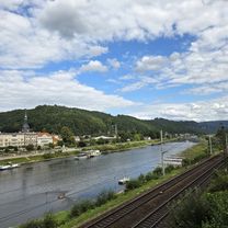
Heidenau, Saxony, Germany.
OverviewAbout this route
-:--
Duration
63.7 km
Distance
704 m
Ascent
704 m
Descent
---
Avg. speed
---
Max. altitude
Fahrrad-XXL Emporoncreated this 14 years ago
Route qualityWaytypes & surfaces along the route
Waytypes
  • Track

    10.8 km17 %
  • Quiet road

    4.5 km7 %
  • Road

    3.2 km5 %
Surfaces

Paved

58 km(91 %)

Unpaved

1.3 km(2 %)
  • Asphalt

    58 km91 %
  • Unpaved (undefined)

    0.6 km1 %
  • Ground

    0.6 km1 %
Route highlightsPoints of interest along the route
  1. Point of interest after 30.5 km

    Verpflegungspunkt Hirschsprung

  2. Point of interest after 42 km

    Verpflegungspunkt Hochwaldtraße

  3. Point of interest after 49.5 km

    Verpflegungspunkt Reinhardtsgrimma

  4. Point of interest after 54 km

    Verpflegungspunkt Lungkwitz

Continue with BikemapUse, edit, or download this cycling route
You would like to ride Artour 2011 64km or customize it for your own trip? Here is what you can do with this Bikemap route:
Free features
Premium features

Free trial for 3 days, or one-time payment. More about Bikemap Premium.

  • Navigate this route on iOS & Android
  • Export a GPX / KML file of this route
  • Create your custom printout (try it for free)
  • Download this route for offline navigation

Discover more Premium features.

Get Bikemap Premium
From our communityOther popular routes starting in Heidenau

Open it in the app