

Sławniowice - Sławniowice (Mikulovice - Ondrzejovice - Rejviz - Horni Udoli - Zlate Hory - Vrbno - Videlsky Krziż - Svyczerna - Pradziad - Svyczerna - Czervenoh
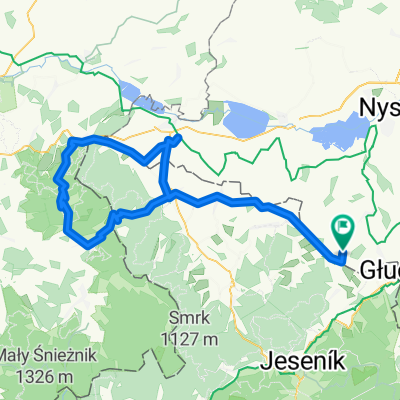
A cycling route starting in Głuchołazy, Opole Voivodeship, Poland.
Overview
About this route
Sławniowice - Mikulovice - Ondrzejovice - Rejviz - Horni Udoli - Zlate Hory - Herzmanovice - Vrbno - Vidly - Videlsky Krziż - Svyczerna - Pradziad - Svyczerna - Czervenohorske Sedlo - Jesenik - Velke Kunietice - Sławniowice
The first part of the route consists mainly of ascents, the rest is practically descent or flat sections.
- -:--
- Duration
- 109.9 km
- Distance
- 1,867 m
- Ascent
- 1,867 m
- Descent
- ---
- Avg. speed
- ---
- Max. altitude

Route quality
Waytypes & surfaces along the route
Waytypes
Track
18.7 km
(17 %)
Quiet road
7.7 km
(7 %)
Surfaces
Paved
68.1 km
(62 %)
Unpaved
7.7 km
(7 %)
Asphalt
65.9 km
(60 %)
Gravel
4.4 km
(4 %)
Continue with Bikemap
Use, edit, or download this cycling route
You would like to ride Sławniowice - Sławniowice (Mikulovice - Ondrzejovice - Rejviz - Horni Udoli - Zlate Hory - Vrbno - Videlsky Krziż - Svyczerna - Pradziad - Svyczerna - Czervenoh or customize it for your own trip? Here is what you can do with this Bikemap route:
Free features
- Save this route as favorite or in collections
- Copy & plan your own version of this route
- Split it into stages to create a multi-day tour
- Sync your route with Garmin or Wahoo
Premium features
Free trial for 3 days, or one-time payment. More about Bikemap Premium.
- Navigate this route on iOS & Android
- Export a GPX / KML file of this route
- Create your custom printout (try it for free)
- Download this route for offline navigation
Discover more Premium features.
Get Bikemap PremiumFrom our community
Other popular routes starting in Głuchołazy
 Trasa rodzinna - Gold Hill MTB Maraton Głuchołazy 2016
- Distance
- 13.2 km
- Ascent
- 417 m
- Descent
- 410 m
- Location
- Głuchołazy, Opole Voivodeship, Poland
 Obóz w Głuchołazach: Wycieczka na Pradziada
- Distance
- 113 km
- Ascent
- 2,309 m
- Descent
- 2,025 m
- Location
- Głuchołazy, Opole Voivodeship, Poland
 chorwacja wegry off
- Distance
- 1,154.1 km
- Ascent
- 1,999 m
- Descent
- 2,278 m
- Location
- Głuchołazy, Opole Voivodeship, Poland
 dookoła Biskupiej Kopy - krotka
- Distance
- 27 km
- Ascent
- 458 m
- Descent
- 457 m
- Location
- Głuchołazy, Opole Voivodeship, Poland
 Sławniowice - Sławniowice (przez Javornik, Lądek Zdrój, Złoty Stok)
- Distance
- 99.9 km
- Ascent
- 930 m
- Descent
- 930 m
- Location
- Głuchołazy, Opole Voivodeship, Poland
 Sławniowice - Wrocław (Grodków, Oława)
- Distance
- 100.1 km
- Ascent
- 65 m
- Descent
- 261 m
- Location
- Głuchołazy, Opole Voivodeship, Poland
 Sławniowice - Sławniowice (Mikulovice - Ondrzejovice - Rejviz - Horni Udoli - Zlate Hory - Vrbno - Videlsky Krziż - Svyczerna - Pradziad - Svyczerna - Czervenoh
- Distance
- 109.9 km
- Ascent
- 1,867 m
- Descent
- 1,867 m
- Location
- Głuchołazy, Opole Voivodeship, Poland
 Głuchołazy - Jesenik - Głuchołazy 12_11_11
- Distance
- 56.3 km
- Ascent
- 1,149 m
- Descent
- 1,149 m
- Location
- Głuchołazy, Opole Voivodeship, Poland
Open it in the app