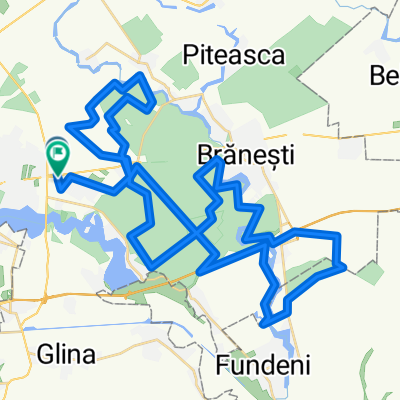
Bucuresti MTB Cernica Green 49 km (ADE 208) Bucuresti - Pd. Pustnicu - raul Pasarea - Pd. Cernica - Cernica - Bucuresti
- 48.8 km
- 189 m
- 192 m
- Pantelimon, Ilfov, Romania
A cycling route starting in Pantelimon, Ilfov, Romania.
Overview
*** August 2022. Route length: 49 km. Offroad /gravel road: 32 km; asphalt /concrete slabs: 17 km
*** description, map & photos by FB page "Green trails MTB outdoor-fun"
*** no car needed
*** Duration: 6h in my case, moderate pace; this duration included enough breaks to admire the scenery, take photos, visit some attractions along the route, and a sandwich break. Bike type: MTB XC hardtail (not an E-bike). The photos were taken on the uploaded route, but may belong to different periods/seasons.
*** My favorites: --- the trail along the river Pasarea between km 21.7 - 23.5 and 24 - 27.4; --- the forest-fast-line in the Pustnicu forest between km 16.8 - 21.7 and in the Cernica forest between km 34.4 - 34.8 and 36.6 - 42.8
*** On the route: the Cernica Orthodox monastery (km 42.8)
*** Metro: towards Pantelimon I opted for the first car, the station having a single exit.
*** Bike self-wash, pay (for example; the stands are, in fact - car self-wash): at km 46.7 (on the right side of the road); at km 47.2 (on the right side of the road)
A ride that includes one of the best single trails I ride near Bucharest - the one that winds along the bank of the Pasarea river for a few kilometers. I really enjoy the offroad sections of this bike trip - traversing the green of the Cernica and Pustnicu forests, with beautiful views of the river, clean air, and relaxation.
The ride starts at the Pantelimon metro station and shortly after - right after crossing the bridge over Lake Cernica - I descended about 7-8 meters down the steep end of the bridge for an incursion onto the promenade along the bank of the lake, and at km 1.2 I left the sidewalk to follow for 150 meters the path also located at the water's edge. The road continues on asphalt until km 7.4 - carefully crossing at km 3.9 the railway (which is in use) and the Ring Road (I passed the same spot on the way back, at km 44.9), after which I entered the Cernica forest on a nice gravel road, which I followed for 1.2 km, continuing afterward on dirt forest paths.
Between km 9.6 - 11.3 I crossed the gravel forest road "Valea Orzului," followed by a dirt forest road with stones until km 12.4, from where I continued on asphalt for about 2.8 km until the Pustnicu forest, entering offroad at km 15.2. After a short stretch on asphalt, a series of very nice dirt forest paths followed - rather a solid forest-fast-line between km 16.8 - 21.7 inviting you to go full-speed and continuing along the bank of the Pasarea river until km 23.5 where I turned right for a short section in the forest, and after crossing DJ 301B there followed another equally nice stretch along the river between km 24 - 27.4.
At km 27.4 I crossed the DN 3 and at km 27.6 the railway - with special care as it is in use (after crossing the DN I continued 100 meters on the path next to the water after which I turned right on a less visible path, and after a few meters I held right then left to climb 5-6 meters towards the railway) and after about 80 meters I continued straight on the path that climbs the small hill at the point where another path branches off to the right. The trail returns to the bank of the Pasarea river between km 28.4 - 30.1 and 31 - 31.2 after which it continues in a beautiful sector of the Cernica forest for 3.2 km. From km 34.4 followed a 1.4 km section of single trail through Crangul Verde, a very flowy forest-fast-line, after which I continued on dirt forest paths until km 37.5 and again on a forest-fast-line inviting full-speed between km 37.5 - 38.5.
After this came a 2 km gravel road, and after a succession of dirt roads and single trails we reached km 42.8 at the asphalt road at the entrance to the Cernica monastery (making a left detour to visit it), and in about 6 km we were back at the starting point of this bike trip.
*** For the part of the tour that takes place on asphalt - I found, in most cases, solutions to avoid heavy traffic - using either sections located next to the road (for example - additional space next to the car lane, green space; or bike lanes where they existed), or streets with less traffic - which for me was safe enough.
Have fun :)
created this 3 years ago
 Bucuresti - Pd. Pustnicu - raul Pasarea - Pd. Cernica - Cernica - Bucuresti\"")
 Bucuresti - Pd. Pustnicu - raul Pasarea - Pd. Cernica - Cernica - Bucuresti\"")
 Bucuresti - Pd. Pustnicu - raul Pasarea - Pd. Cernica - Cernica - Bucuresti\"")
 Bucuresti - Pd. Pustnicu - raul Pasarea - Pd. Cernica - Cernica - Bucuresti\"")
 Bucuresti - Pd. Pustnicu - raul Pasarea - Pd. Cernica - Cernica - Bucuresti\"")
 Bucuresti - Pd. Pustnicu - raul Pasarea - Pd. Cernica - Cernica - Bucuresti\"")
 Bucuresti - Pd. Pustnicu - raul Pasarea - Pd. Cernica - Cernica - Bucuresti\"")
 Bucuresti - Pd. Pustnicu - raul Pasarea - Pd. Cernica - Cernica - Bucuresti\"")
Continue with Bikemap
You would like to ride Bucuresti MTB Cernica Green 49 km (ADE 208) Bucuresti - Pd. Pustnicu - raul Pasarea - Pd. Cernica - Cernica - Bucuresti or customize it for your own trip? Here is what you can do with this Bikemap route:
Free trial for 3 days, or one-time payment. More about Bikemap Premium.
Discover more Premium features.
Get Bikemap PremiumFrom our community
Open it in the app