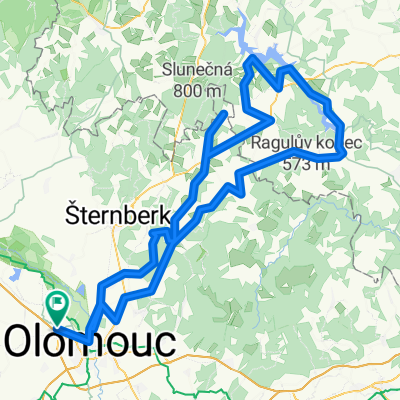
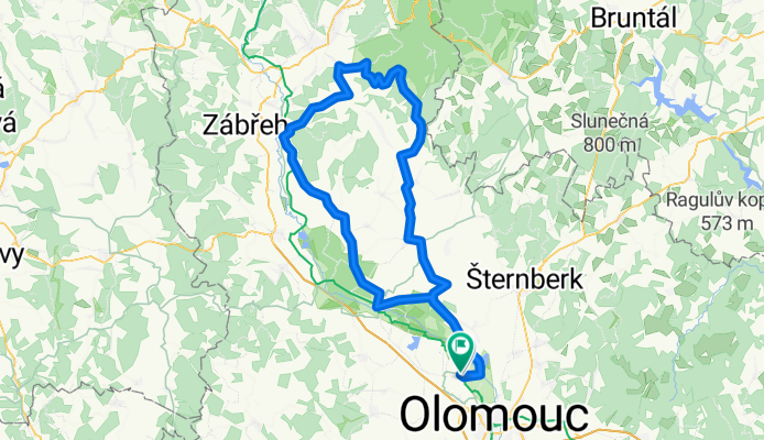
k Sumperku
A cycling route starting in Horka nad Moravou, Olomoucký kraj, Czechia.
Overview
About this route
The more information you write here, the more useful it will be for other users.* Course of the route.* What's special about this route?* Why recommend this route?* What did you like most here?* Etc.
- -:--
- Duration
- 112.8 km
- Distance
- 541 m
- Ascent
- 546 m
- Descent
- ---
- Avg. speed
- ---
- Max. altitude
Route quality
Waytypes & surfaces along the route
Waytypes
Road
36.1 km
(32 %)
Cycleway
7.9 km
(7 %)
Surfaces
Paved
33.8 km
(30 %)
Unpaved
1.1 km
(1 %)
Asphalt
31.6 km
(28 %)
Concrete
2.3 km
(2 %)
Continue with Bikemap
Use, edit, or download this cycling route
You would like to ride k Sumperku or customize it for your own trip? Here is what you can do with this Bikemap route:
Free features
- Save this route as favorite or in collections
- Copy & plan your own version of this route
- Split it into stages to create a multi-day tour
- Sync your route with Garmin or Wahoo
Premium features
Free trial for 3 days, or one-time payment. More about Bikemap Premium.
- Navigate this route on iOS & Android
- Export a GPX / KML file of this route
- Create your custom printout (try it for free)
- Download this route for offline navigation
Discover more Premium features.
Get Bikemap PremiumFrom our community
Other popular routes starting in Horka nad Moravou
- Křelov - Chorvatsko - Křelov 2012
- Distance
- 1,768.3 km
- Ascent
- 1,949 m
- Descent
- 1,949 m
- Location
- Horka nad Moravou, Olomoucký kraj, Czechia
- Křelov - Sv. Kopeček - Hlubočky - Jívová - Dalov - Šternberk - Křelov
- Distance
- 73.4 km
- Ascent
- 731 m
- Descent
- 731 m
- Location
- Horka nad Moravou, Olomoucký kraj, Czechia
- XI.22.7.Patek Olomouc (Horka nad Mor.)-Litomyšl
- Distance
- 94.1 km
- Ascent
- 888 m
- Descent
- 741 m
- Location
- Horka nad Moravou, Olomoucký kraj, Czechia
- okolo Troubelic
- Distance
- 76.7 km
- Ascent
- 225 m
- Descent
- 228 m
- Location
- Horka nad Moravou, Olomoucký kraj, Czechia
- Horka nad Moravou - Olomouc
- Distance
- 9.9 km
- Ascent
- 17 m
- Descent
- 28 m
- Location
- Horka nad Moravou, Olomoucký kraj, Czechia
- Horka - Litovel - Uničov - Horka
- Distance
- 45.3 km
- Ascent
- 58 m
- Descent
- 58 m
- Location
- Horka nad Moravou, Olomoucký kraj, Czechia
- okolo Rabstejna
- Distance
- 138.2 km
- Ascent
- 1,166 m
- Descent
- 1,166 m
- Location
- Horka nad Moravou, Olomoucký kraj, Czechia
- Pastviny 2011
- Distance
- 196.6 km
- Ascent
- 1,612 m
- Descent
- 1,612 m
- Location
- Horka nad Moravou, Olomoucký kraj, Czechia
Open it in the app