
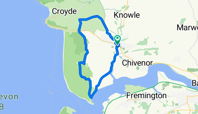
oz mans xc route
A cycling route starting in Braunton, England, United Kingdom.
Overview
About this route
start of the route begins with some killer hills if your novice(which i am, thought lungs and legs would explode) but once on the level its easy enough. the downhill track is short but real fast and a buzz, we we're still talking about it 30 mins later(worth the hill climbs)the rest is fairly easy but you have to keep speed up on track past the great dune due to soft loose sand. which is easy enough just don't turn your bars unless you have to . you will slide. rest of the journey is nice easy flat
- -:--
- Duration
- 17.2 km
- Distance
- 142 m
- Ascent
- 144 m
- Descent
- ---
- Avg. speed
- ---
- Max. altitude
Route quality
Waytypes & surfaces along the route
Waytypes
Quiet road
6.8 km
(39 %)
Cycleway
4.8 km
(28 %)
Surfaces
Paved
0.2 km
(1 %)
Unpaved
4.7 km
(27 %)
Unpaved (undefined)
3.5 km
(20 %)
Sand
1.2 km
(7 %)
Continue with Bikemap
Use, edit, or download this cycling route
You would like to ride oz mans xc route or customize it for your own trip? Here is what you can do with this Bikemap route:
Free features
- Save this route as favorite or in collections
- Copy & plan your own version of this route
- Sync your route with Garmin or Wahoo
Premium features
Free trial for 3 days, or one-time payment. More about Bikemap Premium.
- Navigate this route on iOS & Android
- Export a GPX / KML file of this route
- Create your custom printout (try it for free)
- Download this route for offline navigation
Discover more Premium features.
Get Bikemap PremiumFrom our community
Other popular routes starting in Braunton
 1 st ride out
- Distance
- 18.9 km
- Ascent
- 55 m
- Descent
- 55 m
- Location
- Braunton, England, United Kingdom
 slack jaw
- Distance
- 20.6 km
- Ascent
- 318 m
- Descent
- 318 m
- Location
- Braunton, England, United Kingdom
 braunton to m5
- Distance
- 71.1 km
- Ascent
- 609 m
- Descent
- 528 m
- Location
- Braunton, England, United Kingdom
 sunday ride out 2
- Distance
- 21.6 km
- Ascent
- 376 m
- Descent
- 376 m
- Location
- Braunton, England, United Kingdom
 ride around
- Distance
- 16.2 km
- Ascent
- 146 m
- Descent
- 143 m
- Location
- Braunton, England, United Kingdom
 pint
pint- Distance
- 14.5 km
- Ascent
- 200 m
- Descent
- 199 m
- Location
- Braunton, England, United Kingdom
 Long ride over exmoor
- Distance
- 141 km
- Ascent
- 2,180 m
- Descent
- 2,182 m
- Location
- Braunton, England, United Kingdom
 windfarm loop
- Distance
- 14.8 km
- Ascent
- 265 m
- Descent
- 262 m
- Location
- Braunton, England, United Kingdom
Open it in the app