
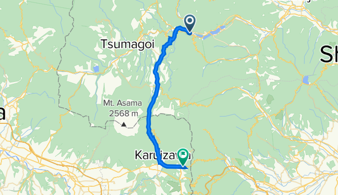
長野原草津口→軽井沢
A cycling route starting in Nakanojōmachi, Gunma, Japan.
Overview
About this route
- 1 h 54 min
- Duration
- 33.4 km
- Distance
- 1,045 m
- Ascent
- 681 m
- Descent
- 17.6 km/h
- Avg. speed
- 1,407 m
- Max. altitude

Continue with Bikemap
Use, edit, or download this cycling route
You would like to ride 長野原草津口→軽井沢 or customize it for your own trip? Here is what you can do with this Bikemap route:
Free features
- Save this route as favorite or in collections
- Copy & plan your own version of this route
- Sync your route with Garmin or Wahoo
Premium features
Free trial for 3 days, or one-time payment. More about Bikemap Premium.
- Navigate this route on iOS & Android
- Export a GPX / KML file of this route
- Create your custom printout (try it for free)
- Download this route for offline navigation
Discover more Premium features.
Get Bikemap PremiumFrom our community
Other popular routes starting in Nakanojōmachi
 中之条・草津
- Distance
- 70.6 km
- Ascent
- 3,259 m
- Descent
- 3,267 m
- Location
- Nakanojōmachi, Gunma, Japan
 Kamisawatari, Nakanojo to 2-chōme 12, Maebashi
- Distance
- 48.5 km
- Ascent
- 573 m
- Descent
- 1,200 m
- Location
- Nakanojōmachi, Gunma, Japan
 R2008/10/10草津-渋温泉
- Distance
- 58.1 km
- Ascent
- 1,710 m
- Descent
- 1,613 m
- Location
- Nakanojōmachi, Gunma, Japan
 Nakanojo to 2-chōme 12, Maebashi
- Distance
- 44.9 km
- Ascent
- 451 m
- Descent
- 897 m
- Location
- Nakanojōmachi, Gunma, Japan
 1157, Sarugakyoonsen, Minakami, Tone-Gun to 2431, Yuzawa, Yuzawa, Minamiuonuma-Gun
- Distance
- 37 km
- Ascent
- 1,254 m
- Descent
- 1,504 m
- Location
- Nakanojōmachi, Gunma, Japan
 Numata
- Distance
- 24.1 km
- Ascent
- 478 m
- Descent
- 433 m
- Location
- Nakanojōmachi, Gunma, Japan
 2013/10/06四万-榛名湖
- Distance
- 63.2 km
- Ascent
- 904 m
- Descent
- 1,555 m
- Location
- Nakanojōmachi, Gunma, Japan
 Nakanojo to 2-chōme 12, Maebashi
- Distance
- 46.3 km
- Ascent
- 471 m
- Descent
- 917 m
- Location
- Nakanojōmachi, Gunma, Japan
Open it in the app