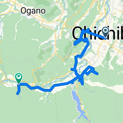
秩父市→児玉
A cycling route starting in Chichibu, Saitama, Japan.
Overview
About this route
- 3 h 12 min
- Duration
- 60 km
- Distance
- 2,495 m
- Ascent
- 2,627 m
- Descent
- 18.7 km/h
- Avg. speed
- 748 m
- Max. altitude
Continue with Bikemap
Use, edit, or download this cycling route
You would like to ride 秩父市→児玉 or customize it for your own trip? Here is what you can do with this Bikemap route:
Free features
- Save this route as favorite or in collections
- Copy & plan your own version of this route
- Sync your route with Garmin or Wahoo
Premium features
Free trial for 3 days, or one-time payment. More about Bikemap Premium.
- Navigate this route on iOS & Android
- Export a GPX / KML file of this route
- Create your custom printout (try it for free)
- Download this route for offline navigation
Discover more Premium features.
Get Bikemap PremiumFrom our community
Other popular routes starting in Chichibu
お祭りを感じるコース- Distance
- 7.1 km
- Ascent
- 0 m
- Descent
- 0 m
- Location
- Chichibu, Saitama, Japan
浦山口駅to飯能駅- Distance
- 41.9 km
- Ascent
- 1,498 m
- Descent
- 1,630 m
- Location
- Chichibu, Saitama, Japan
定峰峠と林道丸山線- Distance
- 40.3 km
- Ascent
- 1,676 m
- Descent
- 1,678 m
- Location
- Chichibu, Saitama, Japan
秩父-志賀坂-十国-麦草-茅野- Distance
- 147.3 km
- Ascent
- 2,937 m
- Descent
- 2,379 m
- Location
- Chichibu, Saitama, Japan
秩父市→児玉- Distance
- 60 km
- Ascent
- 2,495 m
- Descent
- 2,627 m
- Location
- Chichibu, Saitama, Japan
街なか札所巡り~その①~- Distance
- 5.5 km
- Ascent
- 0 m
- Descent
- 0 m
- Location
- Chichibu, Saitama, Japan
街なか札所巡り~その②~- Distance
- 7.5 km
- Ascent
- 0 m
- Descent
- 0 m
- Location
- Chichibu, Saitama, Japan
レトロな街並みコース- Distance
- 4.1 km
- Ascent
- 0 m
- Descent
- 0 m
- Location
- Chichibu, Saitama, Japan
Open it in the app


