

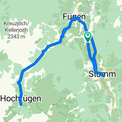
Gießenweg, Fügen nach Achenseestraße 63, Eben am Achensee
A cycling route starting in Uderns, Tyrol, Austria.
Overview
About this route
- 1 h 29 min
- Duration
- 23.3 km
- Distance
- 1,276 m
- Ascent
- 884 m
- Descent
- 15.7 km/h
- Avg. speed
- 970 m
- Max. altitude

Route quality
Waytypes & surfaces along the route
Waytypes
Track
15.1 km
(65 %)
Quiet road
3.5 km
(15 %)
Surfaces
Paved
20 km
(86 %)
Unpaved
3.3 km
(14 %)
Asphalt
19.5 km
(84 %)
Gravel
3 km
(13 %)
Continue with Bikemap
Use, edit, or download this cycling route
You would like to ride Gießenweg, Fügen nach Achenseestraße 63, Eben am Achensee or customize it for your own trip? Here is what you can do with this Bikemap route:
Free features
- Save this route as favorite or in collections
- Copy & plan your own version of this route
- Sync your route with Garmin or Wahoo
Premium features
Free trial for 3 days, or one-time payment. More about Bikemap Premium.
- Navigate this route on iOS & Android
- Export a GPX / KML file of this route
- Create your custom printout (try it for free)
- Download this route for offline navigation
Discover more Premium features.
Get Bikemap PremiumFrom our community
Other popular routes starting in Uderns
 Stummerberg -> Kreuzjochhütte -> Kreuzjochalm -> Karspitz(Fuß) -> Fichtensee/Fichtenschloss -> Diestelberg
- Distance
- 46.2 km
- Ascent
- 1,729 m
- Descent
- 1,734 m
- Location
- Uderns, Tyrol, Austria
 Zillertaler Höhenstraße taleinwärts
- Distance
- 28.4 km
- Ascent
- 2,273 m
- Descent
- 788 m
- Location
- Uderns, Tyrol, Austria
 Etappe 1 - Walchsee
- Distance
- 72.4 km
- Ascent
- 487 m
- Descent
- 369 m
- Location
- Uderns, Tyrol, Austria
 Kirchweg 28, Uderns nach Brandbergstraße 369, Mayrhofen
- Distance
- 21.5 km
- Ascent
- 253 m
- Descent
- 127 m
- Location
- Uderns, Tyrol, Austria
 GdT 2021 - Tappa 2
- Distance
- 54.9 km
- Ascent
- 2,055 m
- Descent
- 2,055 m
- Location
- Uderns, Tyrol, Austria
 Höhenstraße
- Distance
- 55.3 km
- Ascent
- 1,873 m
- Descent
- 1,882 m
- Location
- Uderns, Tyrol, Austria
 Route nach Zillertal-Bundesstraße, Uderns
- Distance
- 0.2 km
- Ascent
- 0 m
- Descent
- 0 m
- Location
- Uderns, Tyrol, Austria
 stumm hoch fugen
- Distance
- 51.1 km
- Ascent
- 981 m
- Descent
- 979 m
- Location
- Uderns, Tyrol, Austria
Open it in the app