

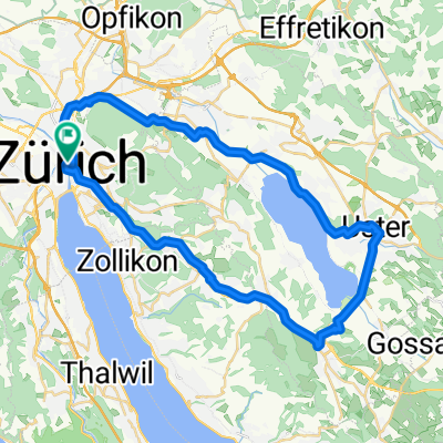
Cyklotrip 2011 - den 1
A cycling route starting in Zürich (Kreis 1) / Lindenhof, Canton of Zurich, Switzerland.
Overview
About this route
Trasa prvního dne našeho cyklotripu z nádraží v Zürichu až do místa přespání v Lichtenštejnsku. Kolem jednoho z jezer vede cyklostezka, kterou jsem nedokázal najít, stejně tak jsme se vyhýbali na některých místech silnici a použili jsme alternativní trasu po cyklostezce.
- -:--
- Duration
- 130 km
- Distance
- 650 m
- Ascent
- 586 m
- Descent
- ---
- Avg. speed
- ---
- Max. altitude
Continue with Bikemap
Use, edit, or download this cycling route
You would like to ride Cyklotrip 2011 - den 1 or customize it for your own trip? Here is what you can do with this Bikemap route:
Free features
- Save this route as favorite or in collections
- Copy & plan your own version of this route
- Split it into stages to create a multi-day tour
- Sync your route with Garmin or Wahoo
Premium features
Free trial for 3 days, or one-time payment. More about Bikemap Premium.
- Navigate this route on iOS & Android
- Export a GPX / KML file of this route
- Create your custom printout (try it for free)
- Download this route for offline navigation
Discover more Premium features.
Get Bikemap PremiumFrom our community
Other popular routes starting in Zürich (Kreis 1) / Lindenhof
 Zurich to Rapperswil-Jona day ride
- Distance
- 33.8 km
- Ascent
- 281 m
- Descent
- 289 m
- Location
- Zürich (Kreis 1) / Lindenhof, Canton of Zurich, Switzerland
 penzello
- Distance
- 100.9 km
- Ascent
- 1,458 m
- Descent
- 1,076 m
- Location
- Zürich (Kreis 1) / Lindenhof, Canton of Zurich, Switzerland
 Uster - Greifensee
- Distance
- 42.6 km
- Ascent
- 370 m
- Descent
- 370 m
- Location
- Zürich (Kreis 1) / Lindenhof, Canton of Zurich, Switzerland
 Cyklodovolená 2017 1.den
- Distance
- 91.7 km
- Ascent
- 1,407 m
- Descent
- 785 m
- Location
- Zürich (Kreis 1) / Lindenhof, Canton of Zurich, Switzerland
 Zürich - Rapperswil
- Distance
- 44.2 km
- Ascent
- 34 m
- Descent
- 32 m
- Location
- Zürich (Kreis 1) / Lindenhof, Canton of Zurich, Switzerland
 Drei Voralpenpässe, Albispass, Ratenpass, Sattelegg
- Distance
- 129.6 km
- Ascent
- 1,792 m
- Descent
- 1,784 m
- Location
- Zürich (Kreis 1) / Lindenhof, Canton of Zurich, Switzerland
 Zurich to Stein am Rhein
- Distance
- 58.9 km
- Ascent
- 732 m
- Descent
- 740 m
- Location
- Zürich (Kreis 1) / Lindenhof, Canton of Zurich, Switzerland
 From Zurich via Greifensee via Pfäffikersee to Zurich
- Distance
- 58 km
- Ascent
- 532 m
- Descent
- 532 m
- Location
- Zürich (Kreis 1) / Lindenhof, Canton of Zurich, Switzerland
Open it in the app