

Strobl 1.day
A cycling route starting in Strobl, Salzburg, Austria.
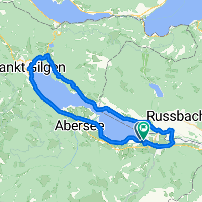
Overview
About this route
Od 9. do 10. kilometru extrémně prudké.
- -:--
- Duration
- 29.4 km
- Distance
- 368 m
- Ascent
- 365 m
- Descent
- ---
- Avg. speed
- 800 m
- Max. altitude

Continue with Bikemap
Use, edit, or download this cycling route
You would like to ride Strobl 1.day or customize it for your own trip? Here is what you can do with this Bikemap route:
Free features
- Save this route as favorite or in collections
- Copy & plan your own version of this route
- Sync your route with Garmin or Wahoo
Premium features
Free trial for 3 days, or one-time payment. More about Bikemap Premium.
- Navigate this route on iOS & Android
- Export a GPX / KML file of this route
- Create your custom printout (try it for free)
- Download this route for offline navigation
Discover more Premium features.
Get Bikemap PremiumFrom our community
Other popular routes starting in Strobl
 SKG lang 2: Strobl-Gößl; 66,1km 680hm
- Distance
- 66.1 km
- Ascent
- 871 m
- Descent
- 691 m
- Location
- Strobl, Salzburg, Austria
 Cesta kolem 4 jezer
- Distance
- 63.4 km
- Ascent
- 529 m
- Descent
- 529 m
- Location
- Strobl, Salzburg, Austria
 DI Seerundfahrt Wolfgangsee 32KM 600HM
- Distance
- 32.1 km
- Ascent
- 797 m
- Descent
- 795 m
- Location
- Strobl, Salzburg, Austria
 Postalm
- Distance
- 12.3 km
- Ascent
- 781 m
- Descent
- 261 m
- Location
- Strobl, Salzburg, Austria
 Strobl_Buchberghutte_Strobl
- Distance
- 41.1 km
- Ascent
- 673 m
- Descent
- 677 m
- Location
- Strobl, Salzburg, Austria
 Okolo Wolfgansee
- Distance
- 42.5 km
- Ascent
- 955 m
- Descent
- 954 m
- Location
- Strobl, Salzburg, Austria
 42-STR-SCH-ATT-MON-WOL-STR
- Distance
- 41.6 km
- Ascent
- 686 m
- Descent
- 689 m
- Location
- Strobl, Salzburg, Austria
 Strobl 1.day
- Distance
- 29.4 km
- Ascent
- 368 m
- Descent
- 365 m
- Location
- Strobl, Salzburg, Austria
Open it in the app