

Charnay les Mâcon, Marcilly.
A cycling route starting in Charnay-lès-Mâcon, Bourgogne-Franche-Comté, France.
Overview
About this route
- 3 h 51 min
- Duration
- 58.7 km
- Distance
- 387 m
- Ascent
- 387 m
- Descent
- 15.2 km/h
- Avg. speed
- 339 m
- Max. altitude

Route photos


Route quality
Waytypes & surfaces along the route
Waytypes
Path
49.9 km
(85 %)
Quiet road
5.3 km
(9 %)
Surfaces
Paved
52.2 km
(89 %)
Unpaved
0.6 km
(1 %)
Asphalt
51.6 km
(88 %)
Paved (undefined)
0.6 km
(1 %)
Continue with Bikemap
Use, edit, or download this cycling route
You would like to ride Charnay les Mâcon, Marcilly. or customize it for your own trip? Here is what you can do with this Bikemap route:
Free features
- Save this route as favorite or in collections
- Copy & plan your own version of this route
- Sync your route with Garmin or Wahoo
Premium features
Free trial for 3 days, or one-time payment. More about Bikemap Premium.
- Navigate this route on iOS & Android
- Export a GPX / KML file of this route
- Create your custom printout (try it for free)
- Download this route for offline navigation
Discover more Premium features.
Get Bikemap PremiumFrom our community
Other popular routes starting in Charnay-lès-Mâcon
 Charnay les Mâcon, Marcilly.
- Distance
- 58.7 km
- Ascent
- 387 m
- Descent
- 387 m
- Location
- Charnay-lès-Mâcon, Bourgogne-Franche-Comté, France
 569 Rue Paul Gauguin, Mâcon à 1382 Rue du Beaujolais, Mâcon
- Distance
- 0.1 km
- Ascent
- 0 m
- Descent
- 0 m
- Location
- Charnay-lès-Mâcon, Bourgogne-Franche-Comté, France
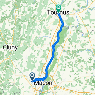 Chemin de Verneuil, Charnay-lès-Mâcon nach Place de l'Hôtel de Ville, Tournus
- Distance
- 38.1 km
- Ascent
- 134 m
- Descent
- 162 m
- Location
- Charnay-lès-Mâcon, Bourgogne-Franche-Comté, France
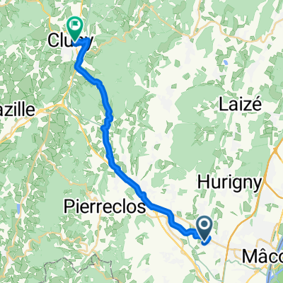 Chemin de Verneuil, Prissé nach Cluny
- Distance
- 21.5 km
- Ascent
- 354 m
- Descent
- 325 m
- Location
- Charnay-lès-Mâcon, Bourgogne-Franche-Comté, France
 FUISSE
- Distance
- 46.8 km
- Ascent
- 702 m
- Descent
- 702 m
- Location
- Charnay-lès-Mâcon, Bourgogne-Franche-Comté, France
 Macon-Paray-le-Monial
- Distance
- 101.4 km
- Ascent
- 696 m
- Descent
- 681 m
- Location
- Charnay-lès-Mâcon, Bourgogne-Franche-Comté, France
 Chemin de la Petite Grosne nach Hôtel de Ville L. Pradel
- Distance
- 86 km
- Ascent
- 267 m
- Descent
- 267 m
- Location
- Charnay-lès-Mâcon, Bourgogne-Franche-Comté, France
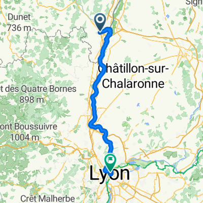
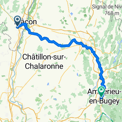 Loché, Mâcon nach Place de la Gare, Ambérieu-en-Bugey
- Distance
- 90.2 km
- Ascent
- 597 m
- Descent
- 543 m
- Location
- Charnay-lès-Mâcon, Bourgogne-Franche-Comté, France
Open it in the app