

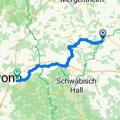
Blau_Schilli_Roth_Schroz_Blau
A cycling route starting in Blaufelden, Baden-Wurttemberg, Germany.
Overview
About this route
- -:--
- Duration
- 66.5 km
- Distance
- 721 m
- Ascent
- 722 m
- Descent
- ---
- Avg. speed
- 543 m
- Max. altitude

Route quality
Waytypes & surfaces along the route
Waytypes
Quiet road
28.6 km
(43 %)
Road
12.6 km
(19 %)
Surfaces
Paved
35.9 km
(54 %)
Unpaved
7.3 km
(11 %)
Asphalt
35.3 km
(53 %)
Gravel
6 km
(9 %)
Continue with Bikemap
Use, edit, or download this cycling route
You would like to ride Blau_Schilli_Roth_Schroz_Blau or customize it for your own trip? Here is what you can do with this Bikemap route:
Free features
- Save this route as favorite or in collections
- Copy & plan your own version of this route
- Sync your route with Garmin or Wahoo
Premium features
Free trial for 3 days, or one-time payment. More about Bikemap Premium.
- Navigate this route on iOS & Android
- Export a GPX / KML file of this route
- Create your custom printout (try it for free)
- Download this route for offline navigation
Discover more Premium features.
Get Bikemap PremiumFrom our community
Other popular routes starting in Blaufelden
 BLauf._Lbg._Hessenau_Amlish._Blauf.
- Distance
- 46.1 km
- Ascent
- 634 m
- Descent
- 650 m
- Location
- Blaufelden, Baden-Wurttemberg, Germany
 Gerabron-Burg Leofels-Lendsiedel-Blaufelden
- Distance
- 42.4 km
- Ascent
- 402 m
- Descent
- 402 m
- Location
- Blaufelden, Baden-Wurttemberg, Germany
 Blau_Schilli_Roth_Schroz_Blau
- Distance
- 66.5 km
- Ascent
- 721 m
- Descent
- 722 m
- Location
- Blaufelden, Baden-Wurttemberg, Germany
 7-Bäche-Tour
- Distance
- 33.6 km
- Ascent
- 310 m
- Descent
- 311 m
- Location
- Blaufelden, Baden-Wurttemberg, Germany
 Stifterweg 13, Blaufelden nach Stifterweg 13, Blaufelden
- Distance
- 69.3 km
- Ascent
- 592 m
- Descent
- 633 m
- Location
- Blaufelden, Baden-Wurttemberg, Germany
 Stifterweg 13, Blaufelden nach Stifterweg 13, Blaufelden
- Distance
- 40.4 km
- Ascent
- 490 m
- Descent
- 482 m
- Location
- Blaufelden, Baden-Wurttemberg, Germany
 Blaufelden - Lehrensteinsfeld
- Distance
- 66.4 km
- Ascent
- 812 m
- Descent
- 1,075 m
- Location
- Blaufelden, Baden-Wurttemberg, Germany
 AfterWork-Tour
- Distance
- 27.7 km
- Ascent
- 270 m
- Descent
- 270 m
- Location
- Blaufelden, Baden-Wurttemberg, Germany
Open it in the app