

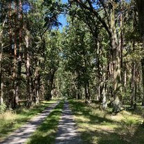
Felder, Wald Seen und evtl. Suppe
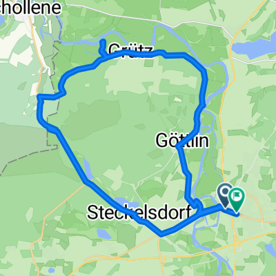
A cycling route starting in Rathenow, Brandenburg, Germany.
Overview
About this route
From Rathenow, it goes over the Jederitzer field and Albertsheim to Hohennauen. From here, along the dyke to Wassersuppe. Over the Havelland main canal and the Ferchesar forest into the town of the same name. From there, along the lake to Semlin. The return is along the country road.
- -:--
- Duration
- 30.6 km
- Distance
- 135 m
- Ascent
- 134 m
- Descent
- ---
- Avg. speed
- 57 m
- Max. altitude

Route quality
Waytypes & surfaces along the route
Waytypes
Quiet road
10.7 km
(35 %)
Path
6.4 km
(21 %)
Surfaces
Paved
17.4 km
(57 %)
Unpaved
6.4 km
(21 %)
Asphalt
15.6 km
(51 %)
Loose gravel
3.4 km
(11 %)
Route highlights
Points of interest along the route
Point of interest after 3.5 km
ehm. sowjetische Bahnlinie
Point of interest after 3.7 km
Wüstung Jederitz
Point of interest after 5.5 km
ehm. Ziegelei Albertsheim
Point of interest after 6 km
ehm. Ziegelei mit Herrenhaus Nordend
Point of interest after 6.5 km
Schloss Hohennauen I
Point of interest after 6.6 km
Dorfkirche mit Wehrturm
Point of interest after 6.7 km
Schloss Hohennauen II
Point of interest after 7.2 km
Badestelle Wassersuppe
Point of interest after 8.8 km
ehm. Ziegelei Glien
Point of interest after 10.6 km
Badestelle Wassersuppe
Point of interest after 10.8 km
ehm. Gutshaus Wassersuppe
Point of interest after 10.8 km
Dorfkirche Wassersuppe
Point of interest after 12 km
Witzker Kanal
Point of interest after 14 km
ehm. Ziegelei Tegeland
Point of interest after 18.1 km
Dorfkirche Ferchesar
Point of interest after 18.5 km
ehm. Schloss Ferchesar
Point of interest after 19 km
Grabstelle derer von Knoblauch
Point of interest after 19.7 km
Wüstung Dranse und Badestelle Dranseschlucht
Point of interest after 23.9 km
Dorfkirche Semlin
Point of interest after 27 km
Marinesiedlung
Point of interest after 27 km
ehm. Chaussehaus Heidekrug
Point of interest after 28.3 km
Kraftfahrerkasernen
Point of interest after 28.8 km
Pionierkasernen (Eiermann)
Point of interest after 29.2 km
Infanteriekasernen
Point of interest after 29.4 km
Nordbahnhof
Continue with Bikemap
Use, edit, or download this cycling route
You would like to ride Felder, Wald Seen und evtl. Suppe or customize it for your own trip? Here is what you can do with this Bikemap route:
Free features
- Save this route as favorite or in collections
- Copy & plan your own version of this route
- Sync your route with Garmin or Wahoo
Premium features
Free trial for 3 days, or one-time payment. More about Bikemap Premium.
- Navigate this route on iOS & Android
- Export a GPX / KML file of this route
- Create your custom printout (try it for free)
- Download this route for offline navigation
Discover more Premium features.
Get Bikemap PremiumFrom our community
Other popular routes starting in Rathenow
 Ackerdörfer-Tour
- Distance
- 74.2 km
- Ascent
- 166 m
- Descent
- 163 m
- Location
- Rathenow, Brandenburg, Germany
 Rathenow nach Am Schlangenhorst, Nauen
- Distance
- 63.2 km
- Ascent
- 181 m
- Descent
- 176 m
- Location
- Rathenow, Brandenburg, Germany
 Hohennauener Straße 22, Rathenow nach Hohennauener Straße 22, Rathenow
- Distance
- 20.2 km
- Ascent
- 77 m
- Descent
- 79 m
- Location
- Rathenow, Brandenburg, Germany
 Sechs Seen Tour
- Distance
- 64.7 km
- Ascent
- 92 m
- Descent
- 92 m
- Location
- Rathenow, Brandenburg, Germany
 perm Kietz
- Distance
- 73.3 km
- Ascent
- 99 m
- Descent
- 98 m
- Location
- Rathenow, Brandenburg, Germany
 Rathenow, südliche Havel (klein)
- Distance
- 28.3 km
- Ascent
- 36 m
- Descent
- 38 m
- Location
- Rathenow, Brandenburg, Germany
 Kirchgang, Rathenow nach Märkischer Platz, Rathenow
- Distance
- 29.4 km
- Ascent
- 441 m
- Descent
- 437 m
- Location
- Rathenow, Brandenburg, Germany
 Von Rathenow bis Perleberg
- Distance
- 101.5 km
- Ascent
- 341 m
- Descent
- 332 m
- Location
- Rathenow, Brandenburg, Germany
Open it in the app