do kozłowki przez las
- 93.2 km
- 280 m
- 281 m
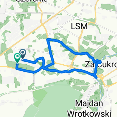
- Kozubszczyzna, Lublin Voivodeship, Poland
A cycling route starting in Kozubszczyzna, Lublin Voivodeship, Poland.
Overview
the route is mainly asphalted, fairly flat, with one steep climb and two descents.
created this 14 years ago
Route quality
Quiet road
17.2 km
60 %
Road
5.7 km
20 %
Paved
22.4 km
(78 %)
Unpaved
3.4 km
(12 %)
Asphalt
22.4 km
78 %
Ground
2.3 km
8 %
Route highlights
zaraz po zjeździe (nie oznakowany) skręt w prawo, dalej kilka dziur w drodze i prosto, aż do "asfaltowego" skrętu w lewo
na odcinku 200 metrów zjazd w dół, koło przystanku autobusowego, skręt w lewo
na skrzyżowaniu koło Jedliny jedziemy prosto
tuż za ogrodzeniem (sadem) nie skręcamy w prawo (droga żużlowa) tylko jedziemy prosto drogą polną (kawałek wzdłuż torów kolejowych) aż do drogi asfaltowej
przed wjazdem do lasu radzę użyć hamulców, gdyż jest kawałek z górki, który jest zakończony szlabanem. Przed szlabanem skręcamy w prawo
Continue with Bikemap
You would like to ride Czarny szlak - Konopnica - Zemborzyce or customize it for your own trip? Here is what you can do with this Bikemap route:
Free trial for 3 days, or one-time payment. More about Bikemap Premium.
Discover more Premium features.
Get Bikemap PremiumFrom our community
Open it in the app