
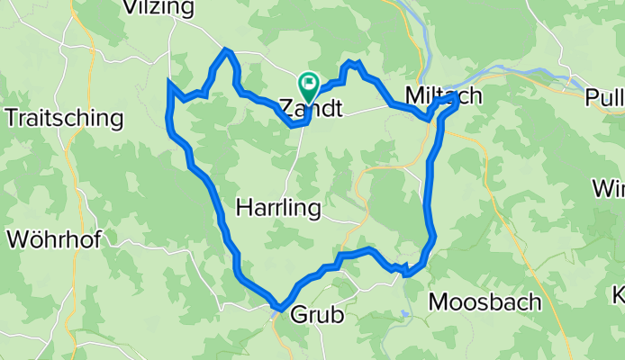
Tour 18: Zandt - Schachendorf - Rissing - Dietersdorf - Altrandsberg - Miltach - Zandt
A cycling route starting in Zandt, Bavaria, Germany.
Overview
About this route
- 1 h 45 min
- Duration
- 25.2 km
- Distance
- 362 m
- Ascent
- 363 m
- Descent
- 14.4 km/h
- Avg. speed
- 568 m
- Max. altitude
Route quality
Waytypes & surfaces along the route
Waytypes
Quiet road
9.9 km
(39 %)
Road
6.9 km
(28 %)
Surfaces
Paved
5.3 km
(21 %)
Unpaved
2.4 km
(9 %)
Asphalt
5.3 km
(21 %)
Loose gravel
2.4 km
(9 %)
Undefined
17.5 km
(70 %)
Continue with Bikemap
Use, edit, or download this cycling route
You would like to ride Tour 18: Zandt - Schachendorf - Rissing - Dietersdorf - Altrandsberg - Miltach - Zandt or customize it for your own trip? Here is what you can do with this Bikemap route:
Free features
- Save this route as favorite or in collections
- Copy & plan your own version of this route
- Sync your route with Garmin or Wahoo
Premium features
Free trial for 3 days, or one-time payment. More about Bikemap Premium.
- Navigate this route on iOS & Android
- Export a GPX / KML file of this route
- Create your custom printout (try it for free)
- Download this route for offline navigation
Discover more Premium features.
Get Bikemap PremiumFrom our community
Other popular routes starting in Zandt
 Liebenau-Hirschenstein
- Distance
- 72.9 km
- Ascent
- 1,350 m
- Descent
- 1,350 m
- Location
- Zandt, Bavaria, Germany
 Birnbrunn
- Distance
- 10.3 km
- Ascent
- 268 m
- Descent
- 271 m
- Location
- Zandt, Bavaria, Germany
 rund um Birnbrunn
- Distance
- 25.8 km
- Ascent
- 635 m
- Descent
- 635 m
- Location
- Zandt, Bavaria, Germany
 Runde von Birnbrunn
- Distance
- 18.2 km
- Ascent
- 437 m
- Descent
- 438 m
- Location
- Zandt, Bavaria, Germany
 Langsame Fahrt in Burghausen
- Distance
- 132.6 km
- Ascent
- 1,240 m
- Descent
- 1,332 m
- Location
- Zandt, Bavaria, Germany
 ?$⁄Ù? nach ?$⁄Ù?
- Distance
- 77.4 km
- Ascent
- 240 m
- Descent
- 240 m
- Location
- Zandt, Bavaria, Germany
 Höllensteinsee
- Distance
- 35.9 km
- Ascent
- 461 m
- Descent
- 951 m
- Location
- Zandt, Bavaria, Germany
 ?$⁄Ù? nach ?$⁄Ù?
- Distance
- 38.7 km
- Ascent
- 70 m
- Descent
- 160 m
- Location
- Zandt, Bavaria, Germany
Open it in the app