

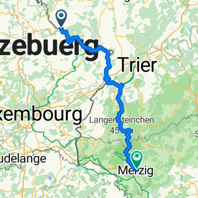
Wallendorf-Wasserbillig-Wormeldange
A cycling route starting in Wallendorf, Rhineland-Palatinate, Germany.
Overview
About this route
- -:--
- Duration
- 55.1 km
- Distance
- 444 m
- Ascent
- 483 m
- Descent
- ---
- Avg. speed
- 211 m
- Max. altitude

Route quality
Waytypes & surfaces along the route
Waytypes
Path
31.4 km
(57 %)
Cycleway
6.6 km
(12 %)
Surfaces
Paved
50.2 km
(91 %)
Asphalt
50.2 km
(91 %)
Undefined
5 km
(9 %)
Continue with Bikemap
Use, edit, or download this cycling route
You would like to ride Wallendorf-Wasserbillig-Wormeldange or customize it for your own trip? Here is what you can do with this Bikemap route:
Free features
- Save this route as favorite or in collections
- Copy & plan your own version of this route
- Sync your route with Garmin or Wahoo
Premium features
Free trial for 3 days, or one-time payment. More about Bikemap Premium.
- Navigate this route on iOS & Android
- Export a GPX / KML file of this route
- Create your custom printout (try it for free)
- Download this route for offline navigation
Discover more Premium features.
Get Bikemap PremiumFrom our community
Other popular routes starting in Wallendorf
 en chemin vers Echternach retour
- Distance
- 15.9 km
- Ascent
- 69 m
- Descent
- 52 m
- Location
- Wallendorf, Rhineland-Palatinate, Germany
 K92 22, Wallendorf to Kapellenstraße 49, Merzig
- Distance
- 85.1 km
- Ascent
- 1,122 m
- Descent
- 1,098 m
- Location
- Wallendorf, Rhineland-Palatinate, Germany
 4-Ländertour: Minden - Koetschette - Petange - Esch - Schengen - Minden
- Distance
- 258.7 km
- Ascent
- 1,027 m
- Descent
- 1,006 m
- Location
- Wallendorf, Rhineland-Palatinate, Germany
 - echternach
- Distance
- 58.2 km
- Ascent
- 1,016 m
- Descent
- 1,090 m
- Location
- Wallendorf, Rhineland-Palatinate, Germany
 VTT berdorf beaufort
- Distance
- 46.8 km
- Ascent
- 1,114 m
- Descent
- 928 m
- Location
- Wallendorf, Rhineland-Palatinate, Germany
 Wallendorf-Wormeldange
- Distance
- 48.1 km
- Ascent
- 495 m
- Descent
- 535 m
- Location
- Wallendorf, Rhineland-Palatinate, Germany
 Wallendorf-Wasserbillig-Wormeldange
- Distance
- 55.1 km
- Ascent
- 444 m
- Descent
- 483 m
- Location
- Wallendorf, Rhineland-Palatinate, Germany
 Rome, Etappe 2, Wallendorf-Pont - Burtoncourt
- Distance
- 120.9 km
- Ascent
- 590 m
- Descent
- 527 m
- Location
- Wallendorf, Rhineland-Palatinate, Germany
Open it in the app