305 Bonifacio Pl, Monterey to 484 Washington St, Monterey
A cycling route starting in Monterey, California, United States.
Overview
About this route
- 3 h 54 min
- Duration
- 63.2 km
- Distance
- 333 m
- Ascent
- 328 m
- Descent
- 16.2 km/h
- Avg. speed
- 54 m
- Max. altitude
Route quality
Waytypes & surfaces along the route
Waytypes
Cycleway
55.9 km
(88 %)
Pedestrian area
4.5 km
(7 %)
Surfaces
Paved
35.9 km
(57 %)
Unpaved
0.3 km
(<1 %)
Paved (undefined)
20.7 km
(33 %)
Concrete
11.4 km
(18 %)
Continue with Bikemap
Use, edit, or download this cycling route
You would like to ride 305 Bonifacio Pl, Monterey to 484 Washington St, Monterey or customize it for your own trip? Here is what you can do with this Bikemap route:
Free features
- Save this route as favorite or in collections
- Copy & plan your own version of this route
- Sync your route with Garmin or Wahoo
Premium features
Free trial for 3 days, or one-time payment. More about Bikemap Premium.
- Navigate this route on iOS & Android
- Export a GPX / KML file of this route
- Create your custom printout (try it for free)
- Download this route for offline navigation
Discover more Premium features.
Get Bikemap PremiumFrom our community
Other popular routes starting in Monterey
- Pier to Pier
- Distance
- 238.4 km
- Ascent
- 1,009 m
- Descent
- 1,009 m
- Location
- Monterey, California, United States
- monterey day 2
- Distance
- 39.1 km
- Ascent
- 299 m
- Descent
- 299 m
- Location
- Monterey, California, United States
- SJ to LA - 02 - Monterey to Morro Bay
- Distance
- 194.8 km
- Ascent
- 1,105 m
- Descent
- 1,102 m
- Location
- Monterey, California, United States
- 74–80 Old Golf Course Rd, Monterey to Salinas
- Distance
- 14 km
- Ascent
- 325 m
- Descent
- 124 m
- Location
- Monterey, California, United States
- Supersonic route in Monterey
- Distance
- 59.9 km
- Ascent
- 0 m
- Descent
- 7 m
- Location
- Monterey, California, United States
- 305 Bonifacio Pl, Monterey to 484 Washington St, Monterey
- Distance
- 63.2 km
- Ascent
- 333 m
- Descent
- 328 m
- Location
- Monterey, California, United States
- Monterey - 17 Mile Drive Loop
- Distance
- 38.7 km
- Ascent
- 624 m
- Descent
- 638 m
- Location
- Monterey, California, United States
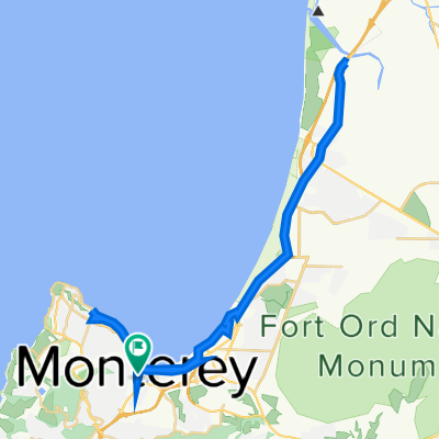
- Monterey to GG via South Peninsula
- Distance
- 194.3 km
- Ascent
- 914 m
- Descent
- 812 m
- Location
- Monterey, California, United States
Open it in the app