

Mosel-Hunsrück-Eifel Mix (103Km)
A cycling route starting in Landkern, Rhineland-Palatinate, Germany.
Overview
About this route
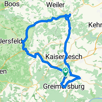
From the starting point to Cochem and along the Moselle to Treis Karden. Over the bridge and up into the Hunsrück. Near Merl along the Moselle to Alf. Continue to Bad Bertrich (note, you must not go through the tunnel but through the town). Up to Kennfus and Lutzerath. Alongside the air base, down into the Laubach valley and back up to Laubach. Easy roll back to the parking lot. Estimated time about 4 hours 15 minutes. Beautiful route, but not without challenges. Good surface, sometimes very little traffic.
- -:--
- Duration
- 103 km
- Distance
- 1,056 m
- Ascent
- 1,056 m
- Descent
- ---
- Avg. speed
- ---
- Max. altitude

Continue with Bikemap
Use, edit, or download this cycling route
You would like to ride Mosel-Hunsrück-Eifel Mix (103Km) or customize it for your own trip? Here is what you can do with this Bikemap route:
Free features
- Save this route as favorite or in collections
- Copy & plan your own version of this route
- Split it into stages to create a multi-day tour
- Sync your route with Garmin or Wahoo
Premium features
Free trial for 3 days, or one-time payment. More about Bikemap Premium.
- Navigate this route on iOS & Android
- Export a GPX / KML file of this route
- Create your custom printout (try it for free)
- Download this route for offline navigation
Discover more Premium features.
Get Bikemap PremiumFrom our community
Other popular routes starting in Landkern
 Alter Post weg nach Cochem
- Distance
- 17.7 km
- Ascent
- 407 m
- Descent
- 407 m
- Location
- Landkern, Rhineland-Palatinate, Germany
 Grosse Acht (67Km)
- Distance
- 67.2 km
- Ascent
- 641 m
- Descent
- 712 m
- Location
- Landkern, Rhineland-Palatinate, Germany
 Mosel - und Eifelmix (70Km)
- Distance
- 69.6 km
- Ascent
- 739 m
- Descent
- 737 m
- Location
- Landkern, Rhineland-Palatinate, Germany
 Durch die Eifel 1 (81Km)
- Distance
- 81.7 km
- Ascent
- 797 m
- Descent
- 797 m
- Location
- Landkern, Rhineland-Palatinate, Germany
 Mosel-Hunsrück-Eifel Mix (103Km)
- Distance
- 103 km
- Ascent
- 1,056 m
- Descent
- 1,056 m
- Location
- Landkern, Rhineland-Palatinate, Germany
 Kleine Runde (44Km)
- Distance
- 43.6 km
- Ascent
- 618 m
- Descent
- 649 m
- Location
- Landkern, Rhineland-Palatinate, Germany
 Landkern-Daun
- Distance
- 32.7 km
- Ascent
- 394 m
- Descent
- 413 m
- Location
- Landkern, Rhineland-Palatinate, Germany
 K24, Illerich to Hauptstraße 34, Kail
- Distance
- 8.6 km
- Ascent
- 73 m
- Descent
- 206 m
- Location
- Landkern, Rhineland-Palatinate, Germany
Open it in the app