

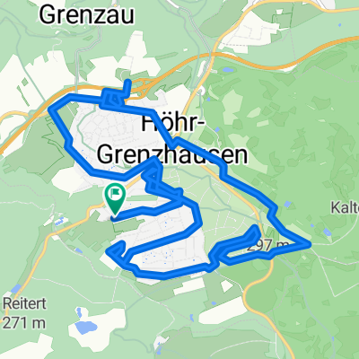
Flürchen-Köppel-Bembermühle-Flürchen 34km
A cycling route starting in Höhr-Grenzhausen, Rhineland-Palatinate, Germany.
Overview
About this route
Start at Waldgaststube Flü rchen in Hö hr-Grenzhausen, forest ascent to Kö ppel with a stop at Kö ppelhü tte (km 6), forest descent down to B 49, past Kadenbach, over Neuhä usel (km 15), forest route into the Kalterbach Valley and to Hillscheid, Limesturm (km 23), forest track to the Bembermü hle beer garden (km 25), forest ascent back to Hö hr-Grenzhausen, through the town to the Ceramic Museum (km 30) and a stop at the destination Waldgaststube Flü rchen.
- -:--
- Duration
- 34 km
- Distance
- 768 m
- Ascent
- 773 m
- Descent
- ---
- Avg. speed
- 554 m
- Max. altitude
Route quality
Waytypes & surfaces along the route
Waytypes
Track
17.7 km
(52 %)
Quiet road
10.5 km
(31 %)
Surfaces
Paved
11.2 km
(33 %)
Unpaved
17.3 km
(51 %)
Asphalt
10.9 km
(32 %)
Gravel
5.8 km
(17 %)
Continue with Bikemap
Use, edit, or download this cycling route
You would like to ride Flürchen-Köppel-Bembermühle-Flürchen 34km or customize it for your own trip? Here is what you can do with this Bikemap route:
Free features
- Save this route as favorite or in collections
- Copy & plan your own version of this route
- Sync your route with Garmin or Wahoo
Premium features
Free trial for 3 days, or one-time payment. More about Bikemap Premium.
- Navigate this route on iOS & Android
- Export a GPX / KML file of this route
- Create your custom printout (try it for free)
- Download this route for offline navigation
Discover more Premium features.
Get Bikemap PremiumFrom our community
Other popular routes starting in Höhr-Grenzhausen
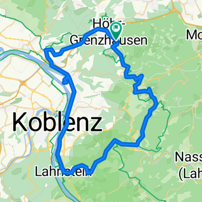
 Höhr - Lahntal -Rheintal -Höhr
- Distance
- 48.5 km
- Ascent
- 815 m
- Descent
- 961 m
- Location
- Höhr-Grenzhausen, Rhineland-Palatinate, Germany
 Rheinstraße nach Rheinstraße
- Distance
- 16.1 km
- Ascent
- 198 m
- Descent
- 245 m
- Location
- Höhr-Grenzhausen, Rhineland-Palatinate, Germany
 Rheinstraße nach Rheinstraße
- Distance
- 14.1 km
- Ascent
- 182 m
- Descent
- 236 m
- Location
- Höhr-Grenzhausen, Rhineland-Palatinate, Germany
 Rheinstraße nach Rheinstraße
- Distance
- 17.4 km
- Ascent
- 214 m
- Descent
- 264 m
- Location
- Höhr-Grenzhausen, Rhineland-Palatinate, Germany
 Rund um Simmern2
- Distance
- 56.1 km
- Ascent
- 394 m
- Descent
- 398 m
- Location
- Höhr-Grenzhausen, Rhineland-Palatinate, Germany
 Rheinstraße nach Rheinstraße
- Distance
- 19.6 km
- Ascent
- 404 m
- Descent
- 330 m
- Location
- Höhr-Grenzhausen, Rhineland-Palatinate, Germany
 Ruhige Route
- Distance
- 17.6 km
- Ascent
- 246 m
- Descent
- 294 m
- Location
- Höhr-Grenzhausen, Rhineland-Palatinate, Germany
 Rheinstraße nach Rheinstraße
- Distance
- 29.6 km
- Ascent
- 443 m
- Descent
- 502 m
- Location
- Höhr-Grenzhausen, Rhineland-Palatinate, Germany
Open it in the app