
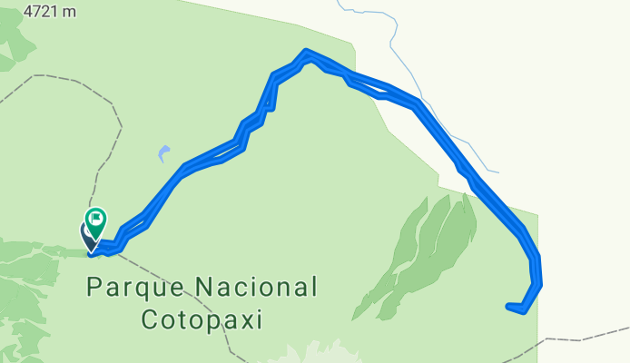
MTB - PN Cotopaxi: Limpiopungo (lake) - Santo Domingo (lake)
A cycling route starting in Machachi, Provincia de Pichincha, Ecuador.
Overview
About this route
RECORRIDO: 40 Km. aprox.
TERRENO: 100% lastre.
PEDALEO PROMEDIO: 5 horas.
NIVEL TECNICO: medio.
NIVEL FISICO: medio.
CICLEABILIDAD: 100%
El inicio de la pedaleada sera en la Laguna de Limpiopungo donde tenemos la bella vista de los cerros Rumiñahui y del espectacular Volcan Cotopaxi.
El camino transcurre en las faldas del Cotopaxi haciendo un ascenso continuo y suave por el camino de la carrera de Aventura Vuelta al Cotopaxi.
Pasaremos por las ruinas arqueologicas de El Salitre, visitaremos las vertientes de agua del Río Pita y llegaremos a la cara oriental del volcan a la laguna de Santo Domingo.
En el camino es posible observar sobre todo aves de Paramo como gallaretas, patos, gaviotas de paramo.
- -:--
- Duration
- 43.1 km
- Distance
- 612 m
- Ascent
- 615 m
- Descent
- ---
- Avg. speed
- ---
- Max. altitude

Continue with Bikemap
Use, edit, or download this cycling route
You would like to ride MTB - PN Cotopaxi: Limpiopungo (lake) - Santo Domingo (lake) or customize it for your own trip? Here is what you can do with this Bikemap route:
Free features
- Save this route as favorite or in collections
- Copy & plan your own version of this route
- Sync your route with Garmin or Wahoo
Premium features
Free trial for 3 days, or one-time payment. More about Bikemap Premium.
- Navigate this route on iOS & Android
- Export a GPX / KML file of this route
- Create your custom printout (try it for free)
- Download this route for offline navigation
Discover more Premium features.
Get Bikemap PremiumFrom our community
Other popular routes starting in Machachi
 RUTA DEL TREN. Machachi - El Boliche. 18 Septiembre 2011. CLONED FROM ROUTE 1250152
- Distance
- 24.7 km
- Ascent
- 694 m
- Descent
- 55 m
- Location
- Machachi, Provincia de Pichincha, Ecuador
 Tour Montaña El Chaupi Día 1
- Distance
- 41.1 km
- Ascent
- 820 m
- Descent
- 820 m
- Location
- Machachi, Provincia de Pichincha, Ecuador
 Aloasi-3 Marías- Chaupi- Aloasi
- Distance
- 40.2 km
- Ascent
- 639 m
- Descent
- 634 m
- Location
- Machachi, Provincia de Pichincha, Ecuador
 Tour Montaña Nestlé Papagayo 80k
- Distance
- 75.5 km
- Ascent
- 1,298 m
- Descent
- 1,298 m
- Location
- Machachi, Provincia de Pichincha, Ecuador
 MTB - Ilinizas
- Distance
- 41.3 km
- Ascent
- 586 m
- Descent
- 722 m
- Location
- Machachi, Provincia de Pichincha, Ecuador
 Tour Montaña Nestlé Papagayo 40k CLONED FROM ROUTE 1759217
- Distance
- 41.1 km
- Ascent
- 903 m
- Descent
- 903 m
- Location
- Machachi, Provincia de Pichincha, Ecuador
 MTB Antenas de la Viudita
- Distance
- 33.1 km
- Ascent
- 1,093 m
- Descent
- 1,094 m
- Location
- Machachi, Provincia de Pichincha, Ecuador
 bike tour through Mejia
- Distance
- 29 km
- Ascent
- 331 m
- Descent
- 573 m
- Location
- Machachi, Provincia de Pichincha, Ecuador
Open it in the app