

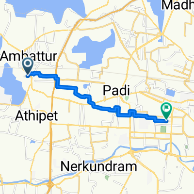
Chennai to Chennai
A cycling route starting in Ambattur, Tamil Nadu, India.
Overview
About this route
- 4 h 1 min
- Duration
- 48.4 km
- Distance
- 298 m
- Ascent
- 295 m
- Descent
- 12.1 km/h
- Avg. speed
- 49 m
- Max. altitude

Route photos

Continue with Bikemap
Use, edit, or download this cycling route
You would like to ride Chennai to Chennai or customize it for your own trip? Here is what you can do with this Bikemap route:
Free features
- Save this route as favorite or in collections
- Copy & plan your own version of this route
- Sync your route with Garmin or Wahoo
Premium features
Free trial for 3 days, or one-time payment. More about Bikemap Premium.
- Navigate this route on iOS & Android
- Export a GPX / KML file of this route
- Create your custom printout (try it for free)
- Download this route for offline navigation
Discover more Premium features.
Get Bikemap PremiumFrom our community
Other popular routes starting in Ambattur
 vlk to sly to sp info city
- Distance
- 49.8 km
- Ascent
- 336 m
- Descent
- 343 m
- Location
- Ambattur, Tamil Nadu, India
 1022-B, Chennai to Service Road, Chennai
- Distance
- 15.4 km
- Ascent
- 59 m
- Descent
- 53 m
- Location
- Ambattur, Tamil Nadu, India
 Adayalampattu
- Distance
- 20.5 km
- Ascent
- 53 m
- Descent
- 59 m
- Location
- Ambattur, Tamil Nadu, India
 Slow ride in Chennai
- Distance
- 10 km
- Ascent
- 4 m
- Descent
- 13 m
- Location
- Ambattur, Tamil Nadu, India
 45QV+34H to 45PV+W8R
- Distance
- 9.5 km
- Ascent
- 116 m
- Descent
- 45 m
- Location
- Ambattur, Tamil Nadu, India
 hhhhhh
- Distance
- 3.5 km
- Ascent
- 3 m
- Descent
- 3 m
- Location
- Ambattur, Tamil Nadu, India
 Moderate route
- Distance
- 6.6 km
- Ascent
- 68 m
- Descent
- 71 m
- Location
- Ambattur, Tamil Nadu, India
 1st Street 9, Chennai to 3rd Main Road 81, Chennai
- Distance
- 4 km
- Ascent
- 57 m
- Descent
- 35 m
- Location
- Ambattur, Tamil Nadu, India
Open it in the app