

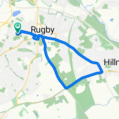
10 Mile Loop - Rugby Town Centre, Canal and Great Central Way
A cycling route starting in Rugby, England, United Kingdom.
Overview
About this route
This is a faily flat circular route from Rugby Town Centre through some scenic areas.
It incorporates a bluebell field, a long stretch of the Oxford Union Canal and most of the Great Central Way.
Subsequently is it a reasonably flat route, however given the off road nature of much of it a mountain bike (with rear suspension or comfortable saddle) is required.
- -:--
- Duration
- 15.8 km
- Distance
- 60 m
- Ascent
- 61 m
- Descent
- ---
- Avg. speed
- ---
- Max. altitude
Continue with Bikemap
Use, edit, or download this cycling route
You would like to ride 10 Mile Loop - Rugby Town Centre, Canal and Great Central Way or customize it for your own trip? Here is what you can do with this Bikemap route:
Free features
- Save this route as favorite or in collections
- Copy & plan your own version of this route
- Sync your route with Garmin or Wahoo
Premium features
Free trial for 3 days, or one-time payment. More about Bikemap Premium.
- Navigate this route on iOS & Android
- Export a GPX / KML file of this route
- Create your custom printout (try it for free)
- Download this route for offline navigation
Discover more Premium features.
Get Bikemap PremiumFrom our community
Other popular routes starting in Rugby
 5mile
5mile- Distance
- 9.1 km
- Ascent
- 120 m
- Descent
- 120 m
- Location
- Rugby, England, United Kingdom
 Pytchley Road 158 to Slade Road 37
- Distance
- 5.6 km
- Ascent
- 137 m
- Descent
- 149 m
- Location
- Rugby, England, United Kingdom
 60K cold ash loop
- Distance
- 59.8 km
- Ascent
- 379 m
- Descent
- 377 m
- Location
- Rugby, England, United Kingdom
 Draycote Water
- Distance
- 47.8 km
- Ascent
- 239 m
- Descent
- 238 m
- Location
- Rugby, England, United Kingdom
 Brownsover loop
- Distance
- 3 km
- Ascent
- 24 m
- Descent
- 25 m
- Location
- Rugby, England, United Kingdom
 Saturday hilly ride
- Distance
- 60.6 km
- Ascent
- 338 m
- Descent
- 338 m
- Location
- Rugby, England, United Kingdom
 Route to 153 Abbey Street, Rugby
- Distance
- 28.4 km
- Ascent
- 1,618 m
- Descent
- 1,610 m
- Location
- Rugby, England, United Kingdom
 Easy Ride
- Distance
- 20.1 km
- Ascent
- 244 m
- Descent
- 240 m
- Location
- Rugby, England, United Kingdom
Open it in the app