

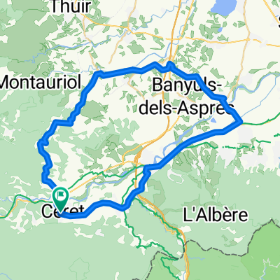
Nice tour starting in Ceret
A cycling route starting in Ceret, Occitanie, France.
Overview
About this route
Nice tour starting in Ceret. As soon as you are leaving the main road in Ceret, traffic is almost absent until oms, then there are a few more cars.
Except for the singletrail at the end the tour is all paved road. I did it on a MTB but the road can be done with a road bike too. The singletrail at the end (starting at the church of St. Feriol) is nice but not easy throughout. If you want to skip it, then just follow the road down to Ceret instead of heading for St. Feriol.
- -:--
- Duration
- 27.7 km
- Distance
- 515 m
- Ascent
- 515 m
- Descent
- ---
- Avg. speed
- ---
- Max. altitude
Route quality
Waytypes & surfaces along the route
Waytypes
Road
18 km
(65 %)
Quiet road
2.5 km
(9 %)
Surfaces
Paved
23.8 km
(86 %)
Asphalt
23.8 km
(86 %)
Undefined
3.9 km
(14 %)
Continue with Bikemap
Use, edit, or download this cycling route
You would like to ride Nice tour starting in Ceret or customize it for your own trip? Here is what you can do with this Bikemap route:
Free features
- Save this route as favorite or in collections
- Copy & plan your own version of this route
- Sync your route with Garmin or Wahoo
Premium features
Free trial for 3 days, or one-time payment. More about Bikemap Premium.
- Navigate this route on iOS & Android
- Export a GPX / KML file of this route
- Create your custom printout (try it for free)
- Download this route for offline navigation
Discover more Premium features.
Get Bikemap PremiumFrom our community
Other popular routes starting in Ceret
 Céret-Col de Llauro-Pleine du Rousillon-Céret
- Distance
- 49.6 km
- Ascent
- 419 m
- Descent
- 422 m
- Location
- Ceret, Occitanie, France
 font frede
- Distance
- 42.4 km
- Ascent
- 1,048 m
- Descent
- 1,044 m
- Location
- Ceret, Occitanie, France
 font frede CLONED FROM ROUTE 1161710
- Distance
- 42.4 km
- Ascent
- 1,048 m
- Descent
- 1,044 m
- Location
- Ceret, Occitanie, France
 Nice tour starting in Ceret
- Distance
- 27.7 km
- Ascent
- 515 m
- Descent
- 515 m
- Location
- Ceret, Occitanie, France
 Céret–Montauriol-Céret
- Distance
- 52.8 km
- Ascent
- 893 m
- Descent
- 920 m
- Location
- Ceret, Occitanie, France
 2008-08---rundtour las illas, coustouges, amelie etc
- Distance
- 87.9 km
- Ascent
- 1,400 m
- Descent
- 1,400 m
- Location
- Ceret, Occitanie, France
 Céret-Oms-Col de Fourtou-Montauriol-Fourques-Céret
- Distance
- 50.2 km
- Ascent
- 848 m
- Descent
- 838 m
- Location
- Ceret, Occitanie, France
 Céret-Oms-Col de Fourtou-Amélie-Céret
- Distance
- 48.8 km
- Ascent
- 875 m
- Descent
- 889 m
- Location
- Ceret, Occitanie, France
Open it in the app