

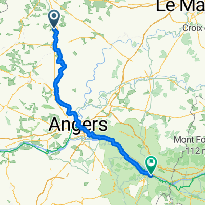
Chemin de Halage Sud, La Roche-Neuville naar 818 Rue Saint-Léonard, Mayenne
A cycling route starting in Quelaines-Saint-Gault, Pays de la Loire Region, France.
Overview
About this route
- 4 h
- Duration
- 62.3 km
- Distance
- 243 m
- Ascent
- 179 m
- Descent
- 15.6 km/h
- Avg. speed
- 121 m
- Max. altitude
Route quality
Waytypes & surfaces along the route
Waytypes
Path
41.7 km
(67 %)
Cycleway
6.2 km
(10 %)
Surfaces
Paved
36.1 km
(58 %)
Unpaved
21.8 km
(35 %)
Paved (undefined)
28 km
(45 %)
Gravel
16.8 km
(27 %)
Continue with Bikemap
Use, edit, or download this cycling route
You would like to ride Chemin de Halage Sud, La Roche-Neuville naar 818 Rue Saint-Léonard, Mayenne or customize it for your own trip? Here is what you can do with this Bikemap route:
Free features
- Save this route as favorite or in collections
- Copy & plan your own version of this route
- Sync your route with Garmin or Wahoo
Premium features
Free trial for 3 days, or one-time payment. More about Bikemap Premium.
- Navigate this route on iOS & Android
- Export a GPX / KML file of this route
- Create your custom printout (try it for free)
- Download this route for offline navigation
Discover more Premium features.
Get Bikemap PremiumFrom our community
Other popular routes starting in Quelaines-Saint-Gault
 De 1 Rue des Pays de la Loire, Quelaines-Saint-Gault à 4 Chemin de la Benatre, Origné
- Distance
- 7.9 km
- Ascent
- 61 m
- Descent
- 58 m
- Location
- Quelaines-Saint-Gault, Pays de la Loire Region, France
 tours de France sept2021 a
- Distance
- 63.4 km
- Ascent
- 200 m
- Descent
- 260 m
- Location
- Quelaines-Saint-Gault, Pays de la Loire Region, France
 Quelaines-Saint-Gault - Saumur
- Distance
- 123.8 km
- Ascent
- 908 m
- Descent
- 856 m
- Location
- Quelaines-Saint-Gault, Pays de la Loire Region, France
 Chemin de Halage Sud, La Roche-Neuville naar 818 Rue Saint-Léonard, Mayenne
- Distance
- 62.3 km
- Ascent
- 243 m
- Descent
- 179 m
- Location
- Quelaines-Saint-Gault, Pays de la Loire Region, France
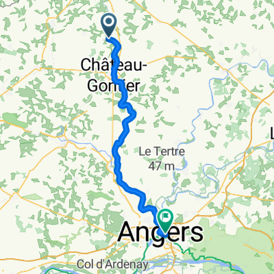 Quelaines-Saint-Gault - Angers
- Distance
- 68.9 km
- Ascent
- 478 m
- Descent
- 507 m
- Location
- Quelaines-Saint-Gault, Pays de la Loire Region, France
 Itinéraire vers ?‰BŸ?
- Distance
- 20 km
- Ascent
- 10 m
- Descent
- 0 m
- Location
- Quelaines-Saint-Gault, Pays de la Loire Region, France
 Quelaines-Saint-Gault - Mayenne
- Distance
- 56.4 km
- Ascent
- 831 m
- Descent
- 787 m
- Location
- Quelaines-Saint-Gault, Pays de la Loire Region, France
Open it in the app